You are here: Home > Network List > KN - Kyrgyz Seismic Telemetry Network Stations List
> Station TKM2 - > Earthquake Result Viewer
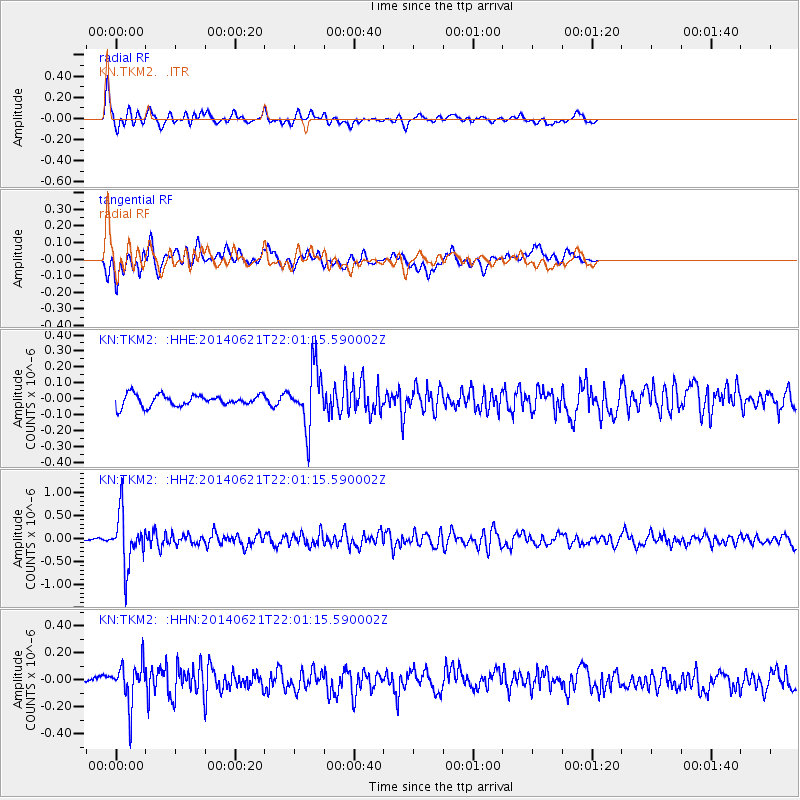
TKM2 - - Earthquake Result Viewer
*The percent match for this event was below the threshold and hence no stack was calculated.
| Earthquake location: |
Minahassa Peninsula, Sulawesi |
| Earthquake latitude/longitude: |
-0.1/123.0 |
| Earthquake time(UTC): |
2014/06/21 (172) 21:51:51 GMT |
| Earthquake Depth: |
115 km |
| Earthquake Magnitude: |
5.5 MB |
| Earthquake Catalog/Contributor: |
NEIC PDE/NEIC COMCAT |
|
| Network: |
KN Kyrgyz Seismic Telemetry Network |
| Station: |
TKM2 - |
| Lat/Lon: |
42.92 N/75.60 E |
| Elevation: |
2020 m |
|
| Distance: |
60.3 deg |
| Az: |
321.496 deg |
| Baz: |
122.056 deg |
| Ray Param: |
$rayparam |
*The percent match for this event was below the threshold and hence was not used in the summary stack. |
|
| Radial Match: |
80.22371 % |
| Radial Bump: |
400 |
| Transverse Match: |
65.6277 % |
| Transverse Bump: |
400 |
| SOD ConfigId: |
3390531 |
| Insert Time: |
2019-04-12 09:28:45.712 +0000 |
| GWidth: |
2.5 |
| Max Bumps: |
400 |
| Tol: |
0.001 |
|
Signal To Noise
| Channel | StoN | STA | LTA |
| KN:TKM2: :HHZ:20140621T22:01:15.590002Z | 11.2011 | 5.457907E-7 | 4.872653E-8 |
| KN:TKM2: :HHN:20140621T22:01:15.590002Z | 4.225187 | 1.5044189E-7 | 3.5605975E-8 |
| KN:TKM2: :HHE:20140621T22:01:15.590002Z | 5.7745724 | 1.8252184E-7 | 3.1607854E-8 |
| Arrivals |
| Ps | |
| PpPs | |
| PsPs/PpSs | |


