You are here: Home > Network List > TA - USArray Transportable Network (new EarthScope stations) Stations List
> Station Z41A Richland Creek Farm, El Dorado, AR, USA > Earthquake Result Viewer
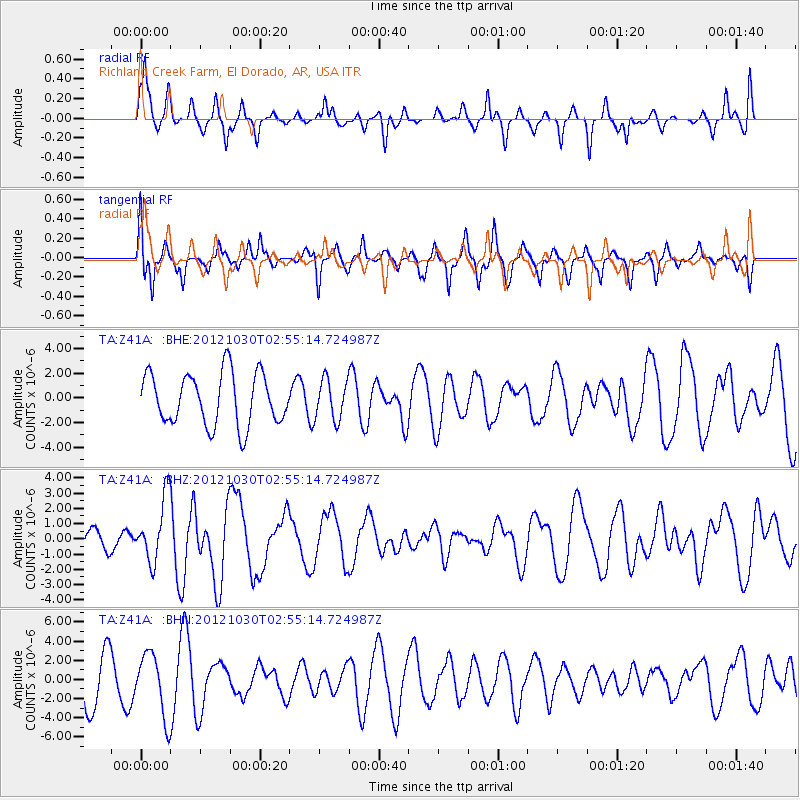
Z41A Richland Creek Farm, El Dorado, AR, USA - Earthquake Result Viewer
*The percent match for this event was below the threshold and hence no stack was calculated.
| Earthquake location: |
Queen Charlotte Islands Region |
| Earthquake latitude/longitude: |
52.4/-131.9 |
| Earthquake time(UTC): |
2012/10/30 (304) 02:49:02 GMT |
| Earthquake Depth: |
9.0 km |
| Earthquake Magnitude: |
5.8 MB, 6.0 MS, 6.2 MW, 6.2 MW |
| Earthquake Catalog/Contributor: |
WHDF/NEIC |
|
| Network: |
TA USArray Transportable Network (new EarthScope stations) |
| Station: |
Z41A Richland Creek Farm, El Dorado, AR, USA |
| Lat/Lon: |
33.26 N/92.80 W |
| Elevation: |
62 m |
|
| Distance: |
33.9 deg |
| Az: |
108.709 deg |
| Baz: |
316.119 deg |
| Ray Param: |
$rayparam |
*The percent match for this event was below the threshold and hence was not used in the summary stack. |
|
| Radial Match: |
54.00892 % |
| Radial Bump: |
337 |
| Transverse Match: |
66.89089 % |
| Transverse Bump: |
381 |
| SOD ConfigId: |
478790 |
| Insert Time: |
2013-03-01 10:07:18.283 +0000 |
| GWidth: |
2.5 |
| Max Bumps: |
400 |
| Tol: |
0.001 |
|
Signal To Noise
| Channel | StoN | STA | LTA |
| TA:Z41A: :BHZ:20121030T02:55:14.724987Z | 2.4466107 | 2.0966181E-6 | 8.56948E-7 |
| TA:Z41A: :BHN:20121030T02:55:14.724987Z | 1.3403273 | 3.2479309E-6 | 2.4232372E-6 |
| TA:Z41A: :BHE:20121030T02:55:14.724987Z | 0.7772449 | 1.6266414E-6 | 2.0928298E-6 |
| Arrivals |
| Ps | |
| PpPs | |
| PsPs/PpSs | |


