You are here: Home > Network List > TA - USArray Transportable Network (new EarthScope stations) Stations List
> Station Y43A Makayla and Karen, Gunnison, MS, USA > Earthquake Result Viewer
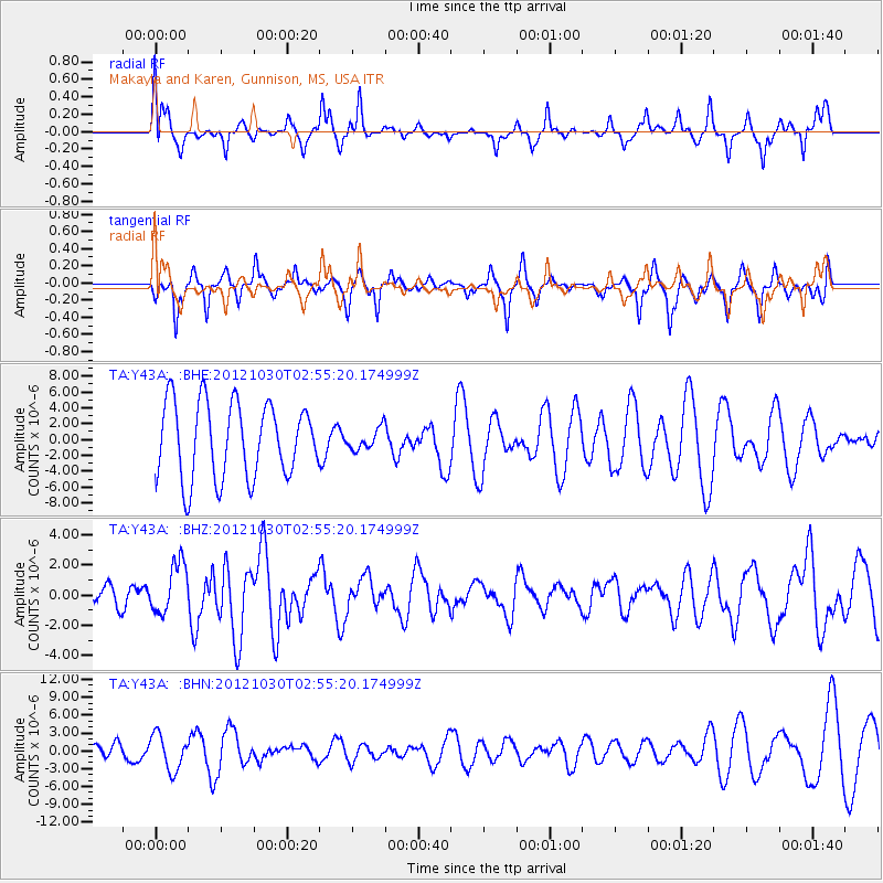
Y43A Makayla and Karen, Gunnison, MS, USA - Earthquake Result Viewer
*The percent match for this event was below the threshold and hence no stack was calculated.
| Earthquake location: |
Queen Charlotte Islands Region |
| Earthquake latitude/longitude: |
52.4/-131.9 |
| Earthquake time(UTC): |
2012/10/30 (304) 02:49:02 GMT |
| Earthquake Depth: |
9.0 km |
| Earthquake Magnitude: |
5.8 MB, 6.0 MS, 6.2 MW, 6.2 MW |
| Earthquake Catalog/Contributor: |
WHDF/NEIC |
|
| Network: |
TA USArray Transportable Network (new EarthScope stations) |
| Station: |
Y43A Makayla and Karen, Gunnison, MS, USA |
| Lat/Lon: |
33.91 N/90.93 W |
| Elevation: |
46 m |
|
| Distance: |
34.5 deg |
| Az: |
105.911 deg |
| Baz: |
314.838 deg |
| Ray Param: |
$rayparam |
*The percent match for this event was below the threshold and hence was not used in the summary stack. |
|
| Radial Match: |
47.677776 % |
| Radial Bump: |
334 |
| Transverse Match: |
51.527817 % |
| Transverse Bump: |
286 |
| SOD ConfigId: |
478790 |
| Insert Time: |
2013-03-01 10:07:37.974 +0000 |
| GWidth: |
2.5 |
| Max Bumps: |
400 |
| Tol: |
0.001 |
|
Signal To Noise
| Channel | StoN | STA | LTA |
| TA:Y43A: :BHZ:20121030T02:55:20.174999Z | 1.812198 | 1.6839631E-6 | 9.292379E-7 |
| TA:Y43A: :BHN:20121030T02:55:20.174999Z | 1.2766731 | 2.9783034E-6 | 2.332863E-6 |
| TA:Y43A: :BHE:20121030T02:55:20.174999Z | 0.28049377 | 1.3300363E-6 | 4.741768E-6 |
| Arrivals |
| Ps | |
| PpPs | |
| PsPs/PpSs | |


