You are here: Home > Network List > TA - USArray Transportable Network (new EarthScope stations) Stations List
> Station U42A Revenden, AR, USA > Earthquake Result Viewer
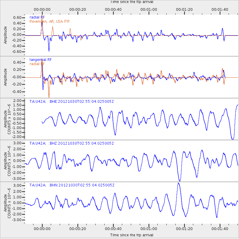
U42A Revenden, AR, USA - Earthquake Result Viewer
*The percent match for this event was below the threshold and hence no stack was calculated.
| Earthquake location: |
Queen Charlotte Islands Region |
| Earthquake latitude/longitude: |
52.4/-131.9 |
| Earthquake time(UTC): |
2012/10/30 (304) 02:49:02 GMT |
| Earthquake Depth: |
9.0 km |
| Earthquake Magnitude: |
5.8 MB, 6.0 MS, 6.2 MW, 6.2 MW |
| Earthquake Catalog/Contributor: |
WHDF/NEIC |
|
| Network: |
TA USArray Transportable Network (new EarthScope stations) |
| Station: |
U42A Revenden, AR, USA |
| Lat/Lon: |
36.35 N/91.24 W |
| Elevation: |
119 m |
|
| Distance: |
32.7 deg |
| Az: |
103.041 deg |
| Baz: |
312.27 deg |
| Ray Param: |
$rayparam |
*The percent match for this event was below the threshold and hence was not used in the summary stack. |
|
| Radial Match: |
47.687325 % |
| Radial Bump: |
350 |
| Transverse Match: |
51.399883 % |
| Transverse Bump: |
400 |
| SOD ConfigId: |
478790 |
| Insert Time: |
2013-03-01 10:08:20.628 +0000 |
| GWidth: |
2.5 |
| Max Bumps: |
400 |
| Tol: |
0.001 |
|
Signal To Noise
| Channel | StoN | STA | LTA |
| TA:U42A: :BHZ:20121030T02:55:04.025005Z | 2.7431784 | 9.871696E-7 | 3.5986346E-7 |
| TA:U42A: :BHN:20121030T02:55:04.025005Z | 0.6992891 | 3.4673656E-7 | 4.958415E-7 |
| TA:U42A: :BHE:20121030T02:55:04.025005Z | 2.0907497 | 7.230399E-7 | 3.4582803E-7 |
| Arrivals |
| Ps | |
| PpPs | |
| PsPs/PpSs | |


