You are here: Home > Network List > TA - USArray Transportable Network (new EarthScope stations) Stations List
> Station P47A Martinsville, IN, USA > Earthquake Result Viewer
P47A Martinsville, IN, USA - Earthquake Result Viewer
| Earthquake location: |
Queen Charlotte Islands Region |
| Earthquake latitude/longitude: |
52.4/-131.9 |
| Earthquake time(UTC): |
2012/10/30 (304) 02:49:02 GMT |
| Earthquake Depth: |
9.0 km |
| Earthquake Magnitude: |
5.8 MB, 6.0 MS, 6.2 MW, 6.2 MW |
| Earthquake Catalog/Contributor: |
WHDF/NEIC |
|
| Network: |
TA USArray Transportable Network (new EarthScope stations) |
| Station: |
P47A Martinsville, IN, USA |
| Lat/Lon: |
39.49 N/86.27 W |
| Elevation: |
246 m |
|
| Distance: |
33.7 deg |
| Az: |
94.04 deg |
| Baz: |
307.775 deg |
| Ray Param: |
0.078097075 |
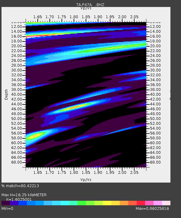
| Estimated Moho Depth: |
16.25 km |
| Estimated Crust Vp/Vs: |
1.60 |
| Assumed Crust Vp: |
6.444 km/s |
| Estimated Crust Vs: |
4.021 km/s |
| Estimated Crust Poisson's Ratio: |
0.18 |
|
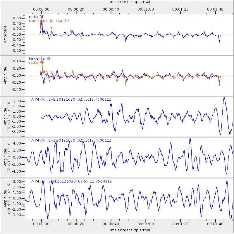
| Radial Match: |
80.42213 % |
| Radial Bump: |
400 |
| Transverse Match: |
72.219185 % |
| Transverse Bump: |
398 |
| SOD ConfigId: |
478790 |
| Insert Time: |
2013-03-01 10:08:57.810 +0000 |
| GWidth: |
2.5 |
| Max Bumps: |
400 |
| Tol: |
0.001 |
|
Signal To Noise
| Channel | StoN | STA | LTA |
| TA:P47A: :BHZ:20121030T02:55:12.750011Z | 1.8492774 | 1.5674193E-6 | 8.475847E-7 |
| TA:P47A: :BHN:20121030T02:55:12.750011Z | 2.3827946 | 2.264217E-6 | 9.50236E-7 |
| TA:P47A: :BHE:20121030T02:55:12.750011Z | 1.698499 | 7.9983766E-7 | 4.7090853E-7 |
| Arrivals |
| Ps | 1.7 SECOND |
| PpPs | 6.0 SECOND |
| PsPs/PpSs | 7.7 SECOND |


