You are here: Home > Network List > TA - USArray Transportable Network (new EarthScope stations) Stations List
> Station J49A Marlette, MI, USA > Earthquake Result Viewer
J49A Marlette, MI, USA - Earthquake Result Viewer
| Earthquake location: |
Queen Charlotte Islands Region |
| Earthquake latitude/longitude: |
52.4/-131.9 |
| Earthquake time(UTC): |
2012/10/30 (304) 02:49:02 GMT |
| Earthquake Depth: |
9.0 km |
| Earthquake Magnitude: |
5.8 MB, 6.0 MS, 6.2 MW, 6.2 MW |
| Earthquake Catalog/Contributor: |
WHDF/NEIC |
|
| Network: |
TA USArray Transportable Network (new EarthScope stations) |
| Station: |
J49A Marlette, MI, USA |
| Lat/Lon: |
43.36 N/83.14 W |
| Elevation: |
253 m |
|
| Distance: |
33.4 deg |
| Az: |
85.856 deg |
| Baz: |
303.013 deg |
| Ray Param: |
0.0782454 |
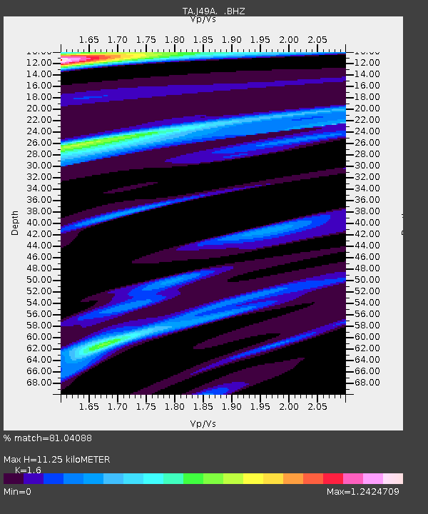
| Estimated Moho Depth: |
11.25 km |
| Estimated Crust Vp/Vs: |
1.60 |
| Assumed Crust Vp: |
6.483 km/s |
| Estimated Crust Vs: |
4.052 km/s |
| Estimated Crust Poisson's Ratio: |
0.18 |
|
| Radial Match: |
81.04088 % |
| Radial Bump: |
400 |
| Transverse Match: |
68.27798 % |
| Transverse Bump: |
309 |
| SOD ConfigId: |
478790 |
| Insert Time: |
2013-03-01 10:12:10.752 +0000 |
| GWidth: |
2.5 |
| Max Bumps: |
400 |
| Tol: |
0.001 |
|
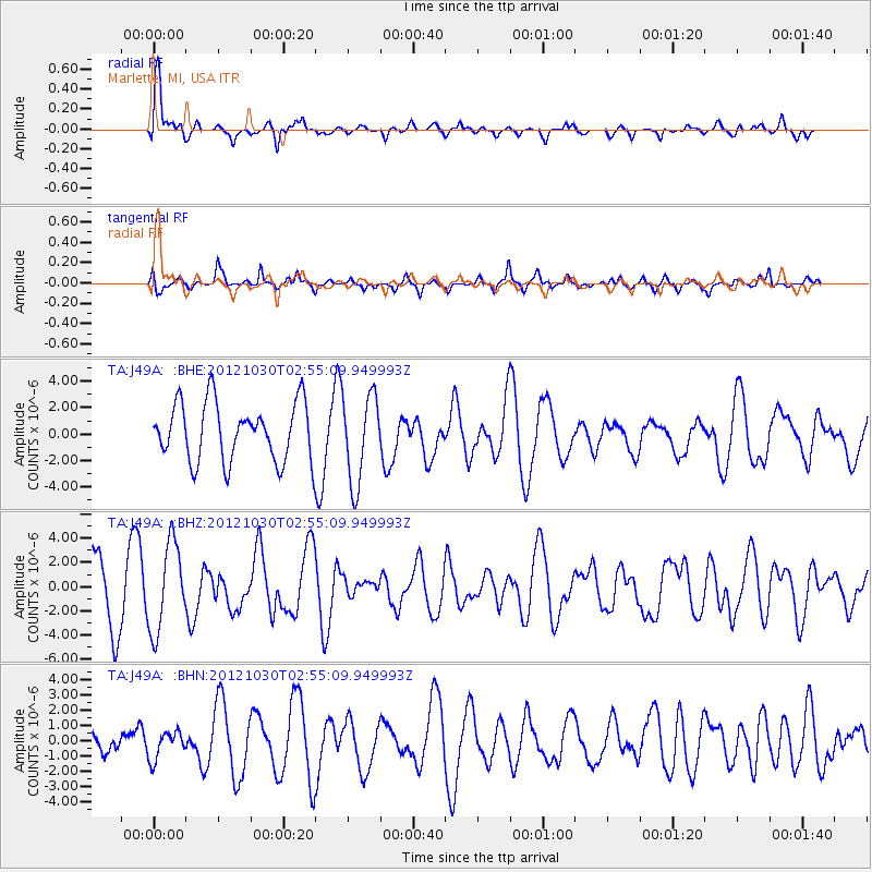
Signal To Noise
| Channel | StoN | STA | LTA |
| TA:J49A: :BHZ:20121030T02:55:09.949993Z | 1.5697285 | 3.6107808E-6 | 2.300258E-6 |
| TA:J49A: :BHN:20121030T02:55:09.949993Z | 0.68723524 | 8.9171346E-7 | 1.2975374E-6 |
| TA:J49A: :BHE:20121030T02:55:09.949993Z | 1.5090762 | 3.317698E-6 | 2.1984958E-6 |
| Arrivals |
| Ps | 1.1 SECOND |
| PpPs | 4.1 SECOND |
| PsPs/PpSs | 5.3 SECOND |


