You are here: Home > Network List > TA - USArray Transportable Network (new EarthScope stations) Stations List
> Station 147A Livingston, AL, USA > Earthquake Result Viewer
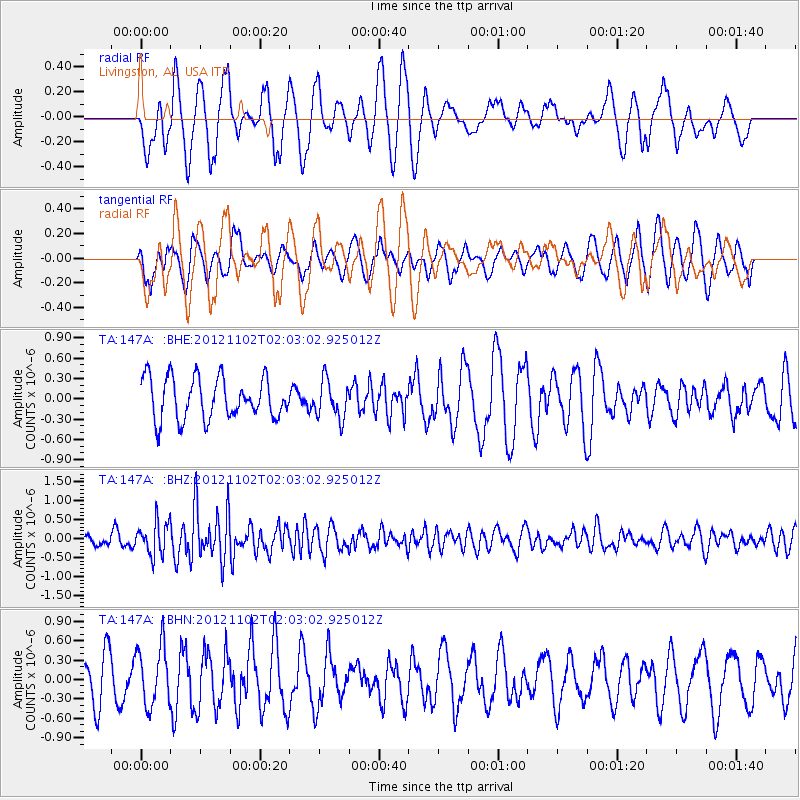
147A Livingston, AL, USA - Earthquake Result Viewer
*The percent match for this event was below the threshold and hence no stack was calculated.
| Earthquake location: |
Near East Coast Of Kamchatka |
| Earthquake latitude/longitude: |
55.9/162.8 |
| Earthquake time(UTC): |
2012/11/02 (307) 01:52:03 GMT |
| Earthquake Depth: |
9.1 km |
| Earthquake Magnitude: |
5.5 MB, 5.4 MS, 5.5 MW, 5.6 MW |
| Earthquake Catalog/Contributor: |
WHDF/NEIC |
|
| Network: |
TA USArray Transportable Network (new EarthScope stations) |
| Station: |
147A Livingston, AL, USA |
| Lat/Lon: |
32.67 N/88.27 W |
| Elevation: |
57 m |
|
| Distance: |
73.2 deg |
| Az: |
56.464 deg |
| Baz: |
326.164 deg |
| Ray Param: |
$rayparam |
*The percent match for this event was below the threshold and hence was not used in the summary stack. |
|
| Radial Match: |
61.512806 % |
| Radial Bump: |
400 |
| Transverse Match: |
51.16225 % |
| Transverse Bump: |
400 |
| SOD ConfigId: |
478790 |
| Insert Time: |
2013-03-01 10:27:59.328 +0000 |
| GWidth: |
2.5 |
| Max Bumps: |
400 |
| Tol: |
0.001 |
|
Signal To Noise
| Channel | StoN | STA | LTA |
| TA:147A: :BHZ:20121102T02:03:02.925012Z | 2.3162725 | 4.370027E-7 | 1.8866636E-7 |
| TA:147A: :BHN:20121102T02:03:02.925012Z | 0.9095582 | 4.5918148E-7 | 5.0484016E-7 |
| TA:147A: :BHE:20121102T02:03:02.925012Z | 0.92547596 | 2.796508E-7 | 3.021697E-7 |
| Arrivals |
| Ps | |
| PpPs | |
| PsPs/PpSs | |


