You are here: Home > Network List > TA - USArray Transportable Network (new EarthScope stations) Stations List
> Station Z47A Carrollton, AL, USA > Earthquake Result Viewer
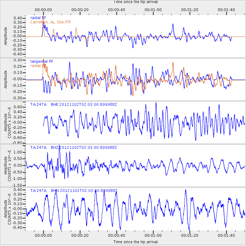
Z47A Carrollton, AL, USA - Earthquake Result Viewer
*The percent match for this event was below the threshold and hence no stack was calculated.
| Earthquake location: |
Near East Coast Of Kamchatka |
| Earthquake latitude/longitude: |
55.9/162.8 |
| Earthquake time(UTC): |
2012/11/02 (307) 01:52:03 GMT |
| Earthquake Depth: |
9.1 km |
| Earthquake Magnitude: |
5.5 MB, 5.4 MS, 5.5 MW, 5.6 MW |
| Earthquake Catalog/Contributor: |
WHDF/NEIC |
|
| Network: |
TA USArray Transportable Network (new EarthScope stations) |
| Station: |
Z47A Carrollton, AL, USA |
| Lat/Lon: |
33.20 N/88.07 W |
| Elevation: |
65 m |
|
| Distance: |
72.8 deg |
| Az: |
56.012 deg |
| Baz: |
326.14 deg |
| Ray Param: |
$rayparam |
*The percent match for this event was below the threshold and hence was not used in the summary stack. |
|
| Radial Match: |
44.62614 % |
| Radial Bump: |
400 |
| Transverse Match: |
49.470734 % |
| Transverse Bump: |
400 |
| SOD ConfigId: |
478790 |
| Insert Time: |
2013-03-01 10:28:11.229 +0000 |
| GWidth: |
2.5 |
| Max Bumps: |
400 |
| Tol: |
0.001 |
|
Signal To Noise
| Channel | StoN | STA | LTA |
| TA:Z47A: :BHZ:20121102T02:03:00.899988Z | 2.2510653 | 3.9048172E-7 | 1.7346531E-7 |
| TA:Z47A: :BHN:20121102T02:03:00.899988Z | 1.3538771 | 2.2481248E-7 | 1.660509E-7 |
| TA:Z47A: :BHE:20121102T02:03:00.899988Z | 1.0865035 | 2.590466E-7 | 2.3842225E-7 |
| Arrivals |
| Ps | |
| PpPs | |
| PsPs/PpSs | |


