You are here: Home > Network List > TA - USArray Transportable Network (new EarthScope stations) Stations List
> Station X44A Crenshaw, MS, USA > Earthquake Result Viewer
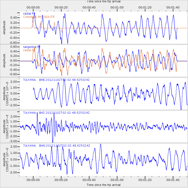
X44A Crenshaw, MS, USA - Earthquake Result Viewer
*The percent match for this event was below the threshold and hence no stack was calculated.
| Earthquake location: |
Near East Coast Of Kamchatka |
| Earthquake latitude/longitude: |
55.9/162.8 |
| Earthquake time(UTC): |
2012/11/02 (307) 01:52:03 GMT |
| Earthquake Depth: |
9.1 km |
| Earthquake Magnitude: |
5.5 MB, 5.4 MS, 5.5 MW, 5.6 MW |
| Earthquake Catalog/Contributor: |
WHDF/NEIC |
|
| Network: |
TA USArray Transportable Network (new EarthScope stations) |
| Station: |
X44A Crenshaw, MS, USA |
| Lat/Lon: |
34.50 N/90.15 W |
| Elevation: |
109 m |
|
| Distance: |
70.8 deg |
| Az: |
56.744 deg |
| Baz: |
325.218 deg |
| Ray Param: |
$rayparam |
*The percent match for this event was below the threshold and hence was not used in the summary stack. |
|
| Radial Match: |
62.259983 % |
| Radial Bump: |
400 |
| Transverse Match: |
56.081997 % |
| Transverse Bump: |
368 |
| SOD ConfigId: |
478790 |
| Insert Time: |
2013-03-01 10:28:35.324 +0000 |
| GWidth: |
2.5 |
| Max Bumps: |
400 |
| Tol: |
0.001 |
|
Signal To Noise
| Channel | StoN | STA | LTA |
| TA:X44A: :BHZ:20121102T02:02:48.625024Z | 3.9002848 | 1.0039214E-6 | 2.5739695E-7 |
| TA:X44A: :BHN:20121102T02:02:48.625024Z | 0.6774606 | 5.475122E-7 | 8.08183E-7 |
| TA:X44A: :BHE:20121102T02:02:48.625024Z | 1.170048 | 1.240782E-6 | 1.060454E-6 |
| Arrivals |
| Ps | |
| PpPs | |
| PsPs/PpSs | |


