You are here: Home > Network List > AG - Arkansas Seismic Network Stations List
> Station HHAR Hobbs,AR > Earthquake Result Viewer
HHAR Hobbs,AR - Earthquake Result Viewer
| Earthquake location: |
Central Peru |
| Earthquake latitude/longitude: |
-13.8/-75.6 |
| Earthquake time(UTC): |
2014/06/22 (173) 18:05:53 GMT |
| Earthquake Depth: |
72 km |
| Earthquake Magnitude: |
5.2 MW |
| Earthquake Catalog/Contributor: |
ISC/ISC |
|
| Network: |
AG Arkansas Seismic Network |
| Station: |
HHAR Hobbs,AR |
| Lat/Lon: |
36.28 N/93.94 W |
| Elevation: |
421 m |
|
| Distance: |
52.7 deg |
| Az: |
341.361 deg |
| Baz: |
157.399 deg |
| Ray Param: |
0.06636976 |
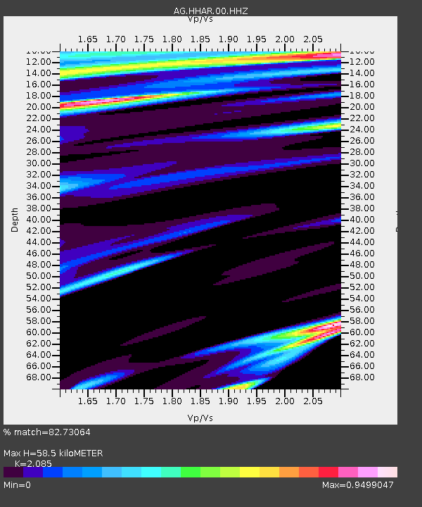
| Estimated Moho Depth: |
58.5 km |
| Estimated Crust Vp/Vs: |
2.09 |
| Assumed Crust Vp: |
6.53 km/s |
| Estimated Crust Vs: |
3.132 km/s |
| Estimated Crust Poisson's Ratio: |
0.35 |
|
| Radial Match: |
82.73064 % |
| Radial Bump: |
313 |
| Transverse Match: |
67.53946 % |
| Transverse Bump: |
369 |
| SOD ConfigId: |
3390531 |
| Insert Time: |
2019-04-12 09:34:29.683 +0000 |
| GWidth: |
2.5 |
| Max Bumps: |
400 |
| Tol: |
0.001 |
|

Signal To Noise
| Channel | StoN | STA | LTA |
| AG:HHAR:00:HHZ:20140622T18:14:30.269978Z | 1.1834584 | 1.2770698E-7 | 1.0790999E-7 |
| AG:HHAR:00:HHN:20140622T18:14:30.269978Z | 1.2545471 | 1.2976514E-7 | 1.03435845E-7 |
| AG:HHAR:00:HHE:20140622T18:14:30.269978Z | 1.0128212 | 1.0739533E-7 | 1.0603582E-7 |
| Arrivals |
| Ps | 10 SECOND |
| PpPs | 26 SECOND |
| PsPs/PpSs | 37 SECOND |


