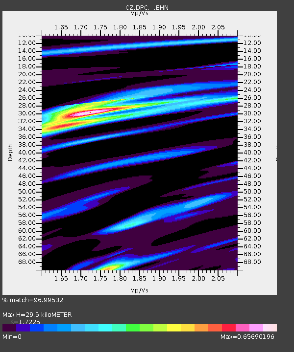
DPC Dobruska, Czech Republic - Earthquake Result Viewer
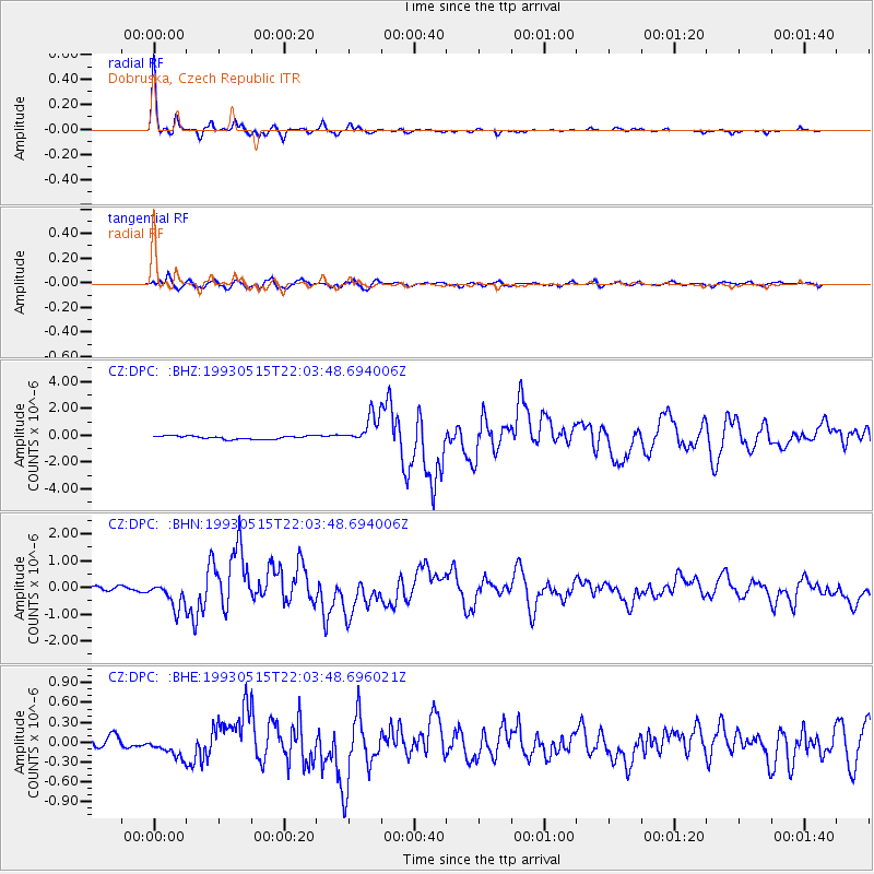
Earthquake location: Andreanof Islands, Aleutian Is.
Earthquake latitude/longitude: 51.3/-178.7
Earthquake time(UTC): 1993/05/15 (135) 21:52:25 GMT
Earthquake Depth: 33 km
Earthquake Magnitude: 6.2 MB, 6.5 MS, 6.3 UNKNOWN, 6.1 ML
Earthquake Catalog/Contributor: WHDF/NEIC
Network: CZ Czech Regional Seismic Network
Station: DPC Dobruska, Czech Republic
Lat/Lon: 50.36 N/16.41 E
Elevation: 760 m
Distance: 77.9 deg
Az: 350.192 deg
Baz: 9.603 deg
Ray Param: 0.04998211
Estimated Moho Depth: 29.5 km
Estimated Crust Vp/Vs: 1.72
Assumed Crust Vp: 6.194 km/s
Estimated Crust Vs: 3.596 km/s
Estimated Crust Poisson's Ratio: 0.25
Radial Match: 96.99532 %
Radial Bump: 236
Transverse Match: 80.06508 %
Transverse Bump: 400
SOD ConfigId: 16938
Insert Time: 2010-02-27 01:10:36.884 +0000
GWidth: 2.5
Max Bumps: 400
Tol: 0.001

Signal To Noise

ChannelStoNSTALTA
CZ:DPC: :BHN:19930515T22:03:48.694006Z7.44133044.813071E-76.468025E-8
CZ:DPC: :BHE:19930515T22:03:48.696021Z1.95700611.5166569E-77.7498825E-8
CZ:DPC: :BHZ:19930515T22:03:48.694006Z9.1468851.0495717E-61.14746356E-7
Arrivals
Ps3.5 SECOND
PpPs13 SECOND
PsPs/PpSs16 SECOND