You are here: Home > Network List > AU - Australian Seismological Centre Stations List
> Station GIRL Giralia, Western Australia > Earthquake Result Viewer
GIRL Giralia, Western Australia - Earthquake Result Viewer
| Earthquake location: |
Mindanao, Philippines |
| Earthquake latitude/longitude: |
9.2/126.2 |
| Earthquake time(UTC): |
2012/11/02 (307) 18:17:32 GMT |
| Earthquake Depth: |
37 km |
| Earthquake Magnitude: |
6.2 MB, 5.7 MS, 6.1 MW, 6.1 MW |
| Earthquake Catalog/Contributor: |
WHDF/NEIC |
|
| Network: |
AU Australian Seismological Centre |
| Station: |
GIRL Giralia, Western Australia |
| Lat/Lon: |
22.64 S/114.23 E |
| Elevation: |
111 m |
|
| Distance: |
33.8 deg |
| Az: |
200.098 deg |
| Baz: |
21.544 deg |
| Ray Param: |
0.077997826 |
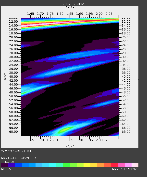
| Estimated Moho Depth: |
14.0 km |
| Estimated Crust Vp/Vs: |
1.61 |
| Assumed Crust Vp: |
6.285 km/s |
| Estimated Crust Vs: |
3.904 km/s |
| Estimated Crust Poisson's Ratio: |
0.19 |
|
| Radial Match: |
91.71341 % |
| Radial Bump: |
332 |
| Transverse Match: |
59.627773 % |
| Transverse Bump: |
400 |
| SOD ConfigId: |
478790 |
| Insert Time: |
2013-03-01 10:36:24.051 +0000 |
| GWidth: |
2.5 |
| Max Bumps: |
400 |
| Tol: |
0.001 |
|

Signal To Noise
| Channel | StoN | STA | LTA |
| AU:GIRL: :BHZ:20121102T18:23:40.520009Z | 4.0263534 | 1.5740791E-6 | 3.909441E-7 |
| AU:GIRL: :BHN:20121102T18:23:40.520009Z | 2.1135035 | 1.0793591E-6 | 5.106967E-7 |
| AU:GIRL: :BHE:20121102T18:23:40.520009Z | 0.9431648 | 7.9818807E-7 | 8.462869E-7 |
| Arrivals |
| Ps | 1.5 SECOND |
| PpPs | 5.4 SECOND |
| PsPs/PpSs | 6.8 SECOND |


