You are here: Home > Network List > G - GEOSCOPE Stations List
> Station DZM Dzumac, New Caledonia > Earthquake Result Viewer
DZM Dzumac, New Caledonia - Earthquake Result Viewer
| Earthquake location: |
Mindanao, Philippines |
| Earthquake latitude/longitude: |
9.2/126.2 |
| Earthquake time(UTC): |
2012/11/02 (307) 18:17:32 GMT |
| Earthquake Depth: |
37 km |
| Earthquake Magnitude: |
6.2 MB, 5.7 MS, 6.1 MW, 6.1 MW |
| Earthquake Catalog/Contributor: |
WHDF/NEIC |
|
| Network: |
G GEOSCOPE |
| Station: |
DZM Dzumac, New Caledonia |
| Lat/Lon: |
22.07 S/166.44 E |
| Elevation: |
878 m |
|
| Distance: |
50.3 deg |
| Az: |
128.757 deg |
| Baz: |
303.905 deg |
| Ray Param: |
0.06808954 |
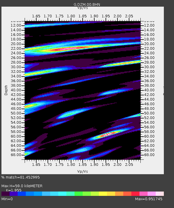
| Estimated Moho Depth: |
59.0 km |
| Estimated Crust Vp/Vs: |
1.96 |
| Assumed Crust Vp: |
5.14 km/s |
| Estimated Crust Vs: |
2.629 km/s |
| Estimated Crust Poisson's Ratio: |
0.32 |
|
| Radial Match: |
81.452995 % |
| Radial Bump: |
400 |
| Transverse Match: |
67.666 % |
| Transverse Bump: |
400 |
| SOD ConfigId: |
478790 |
| Insert Time: |
2013-03-01 10:38:23.054 +0000 |
| GWidth: |
2.5 |
| Max Bumps: |
400 |
| Tol: |
0.001 |
|
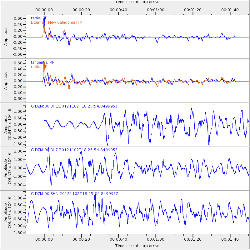
Signal To Noise
| Channel | StoN | STA | LTA |
| G:DZM:00:BHZ:20121102T18:25:54.849995Z | 2.6160338 | 1.0926198E-6 | 4.1766273E-7 |
| G:DZM:00:BHN:20121102T18:25:54.849995Z | 0.8249562 | 4.5763423E-7 | 5.5473765E-7 |
| G:DZM:00:BHE:20121102T18:25:54.849995Z | 3.675258 | 7.20867E-7 | 1.9614052E-7 |
| Arrivals |
| Ps | 11 SECOND |
| PpPs | 33 SECOND |
| PsPs/PpSs | 44 SECOND |


