You are here: Home > Network List > CZ - Czech Regional Seismic Network Stations List
> Station DPC Dobruska, Czech Republic > Earthquake Result Viewer
DPC Dobruska, Czech Republic - Earthquake Result Viewer
| Earthquake location: |
Afghanistan-Tajikistan Bord Reg. |
| Earthquake latitude/longitude: |
36.4/71.6 |
| Earthquake time(UTC): |
1993/09/18 (261) 05:02:27 GMT |
| Earthquake Depth: |
117 km |
| Earthquake Magnitude: |
6.1 MB, 6.4 UNKNOWN, 6.1 MW |
| Earthquake Catalog/Contributor: |
WHDF/NEIC |
|
| Network: |
CZ Czech Regional Seismic Network |
| Station: |
DPC Dobruska, Czech Republic |
| Lat/Lon: |
50.36 N/16.41 E |
| Elevation: |
760 m |
|
| Distance: |
41.5 deg |
| Az: |
307.527 deg |
| Baz: |
87.897 deg |
| Ray Param: |
0.073306076 |
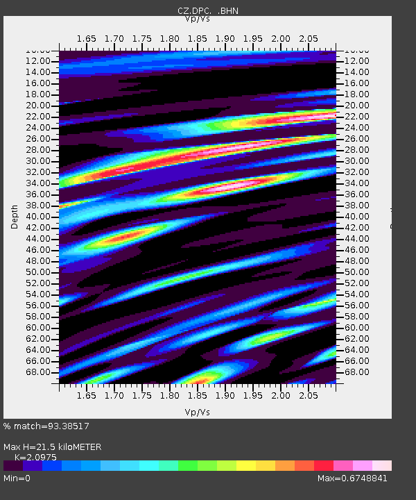
| Estimated Moho Depth: |
21.5 km |
| Estimated Crust Vp/Vs: |
2.10 |
| Assumed Crust Vp: |
6.194 km/s |
| Estimated Crust Vs: |
2.953 km/s |
| Estimated Crust Poisson's Ratio: |
0.35 |
|
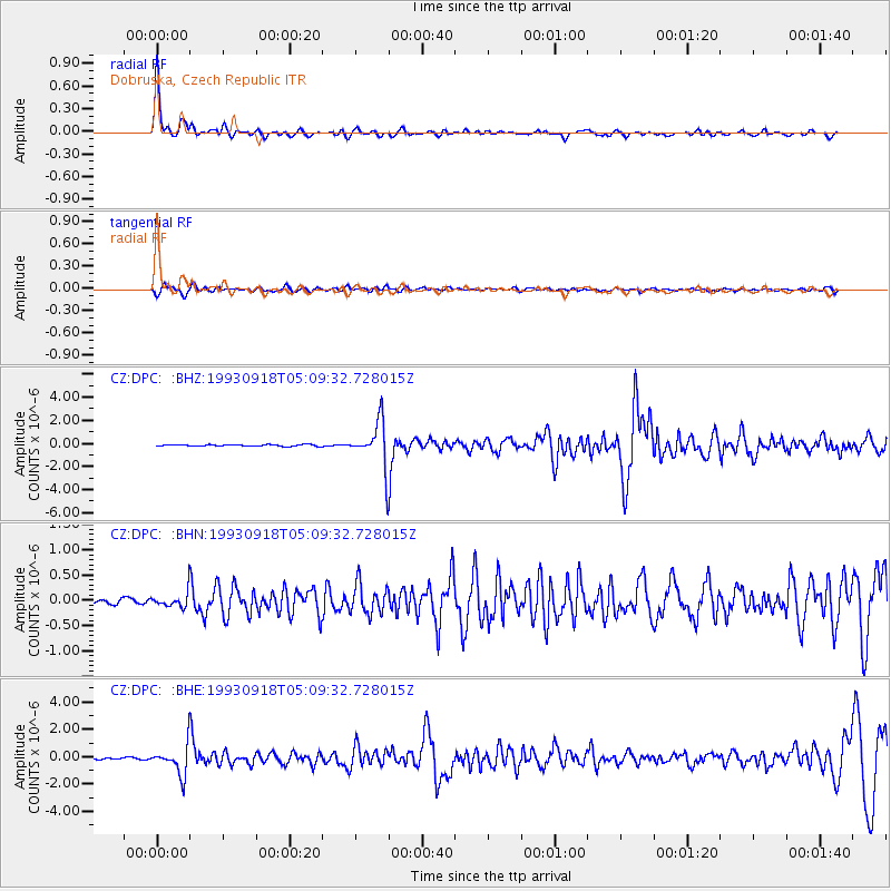
| Radial Match: |
93.38517 % |
| Radial Bump: |
383 |
| Transverse Match: |
75.249626 % |
| Transverse Bump: |
400 |
| SOD ConfigId: |
16938 |
| Insert Time: |
2010-02-27 01:10:49.034 +0000 |
| GWidth: |
2.5 |
| Max Bumps: |
400 |
| Tol: |
0.001 |
|
Signal To Noise
| Channel | StoN | STA | LTA |
| CZ:DPC: :BHN:19930918T05:09:32.728015Z | 3.4311583 | 1.5833821E-7 | 4.614716E-8 |
| CZ:DPC: :BHE:19930918T05:09:32.728015Z | 19.08827 | 1.0978239E-6 | 5.7513013E-8 |
| CZ:DPC: :BHZ:19930918T05:09:32.728015Z | 27.75681 | 1.9602542E-6 | 7.0622455E-8 |
| Arrivals |
| Ps | 4.0 SECOND |
| PpPs | 10 SECOND |
| PsPs/PpSs | 14 SECOND |


