You are here: Home > Network List > TA - USArray Transportable Network (new EarthScope stations) Stations List
> Station BGNE Belgrade, NE, USA > Earthquake Result Viewer
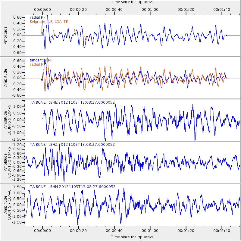
BGNE Belgrade, NE, USA - Earthquake Result Viewer
*The percent match for this event was below the threshold and hence no stack was calculated.
| Earthquake location: |
Central Mid-Atlantic Ridge |
| Earthquake latitude/longitude: |
7.0/-34.1 |
| Earthquake time(UTC): |
2012/11/03 (308) 12:58:12 GMT |
| Earthquake Depth: |
10 km |
| Earthquake Magnitude: |
5.5 MB, 5.2 MS, 5.6 MW, 5.6 MW |
| Earthquake Catalog/Contributor: |
WHDF/NEIC |
|
| Network: |
TA USArray Transportable Network (new EarthScope stations) |
| Station: |
BGNE Belgrade, NE, USA |
| Lat/Lon: |
41.41 N/98.15 W |
| Elevation: |
573 m |
|
| Distance: |
66.0 deg |
| Az: |
312.222 deg |
| Baz: |
102.274 deg |
| Ray Param: |
$rayparam |
*The percent match for this event was below the threshold and hence was not used in the summary stack. |
|
| Radial Match: |
57.162895 % |
| Radial Bump: |
400 |
| Transverse Match: |
58.22165 % |
| Transverse Bump: |
400 |
| SOD ConfigId: |
478790 |
| Insert Time: |
2013-03-01 10:53:33.863 +0000 |
| GWidth: |
2.5 |
| Max Bumps: |
400 |
| Tol: |
0.001 |
|
Signal To Noise
| Channel | StoN | STA | LTA |
| TA:BGNE: :BHZ:20121103T13:08:27.600005Z | 1.9269922 | 5.2028105E-7 | 2.6999646E-7 |
| TA:BGNE: :BHN:20121103T13:08:27.600005Z | 1.0748386 | 6.0545847E-7 | 5.6330174E-7 |
| TA:BGNE: :BHE:20121103T13:08:27.600005Z | 0.8655164 | 4.9939905E-7 | 5.769955E-7 |
| Arrivals |
| Ps | |
| PpPs | |
| PsPs/PpSs | |


