You are here: Home > Network List > TA - USArray Transportable Network (new EarthScope stations) Stations List
> Station M51A Elyria, OH, USA > Earthquake Result Viewer
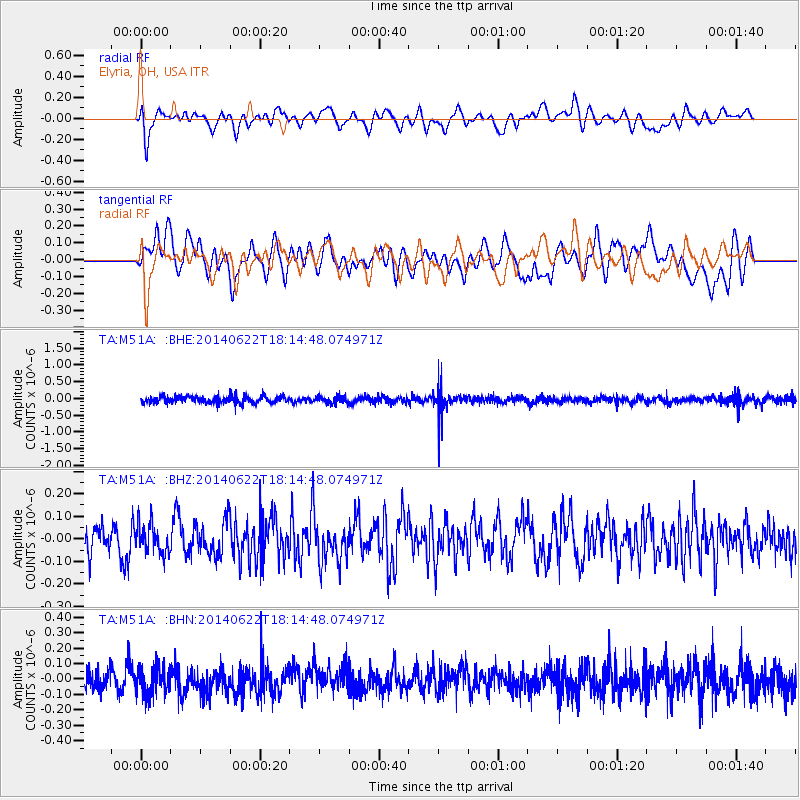
M51A Elyria, OH, USA - Earthquake Result Viewer
*The percent match for this event was below the threshold and hence no stack was calculated.
| Earthquake location: |
Central Peru |
| Earthquake latitude/longitude: |
-13.8/-75.6 |
| Earthquake time(UTC): |
2014/06/22 (173) 18:05:53 GMT |
| Earthquake Depth: |
72 km |
| Earthquake Magnitude: |
5.2 MW |
| Earthquake Catalog/Contributor: |
ISC/ISC |
|
| Network: |
TA USArray Transportable Network (new EarthScope stations) |
| Station: |
M51A Elyria, OH, USA |
| Lat/Lon: |
41.33 N/82.18 W |
| Elevation: |
239 m |
|
| Distance: |
55.2 deg |
| Az: |
353.958 deg |
| Baz: |
172.196 deg |
| Ray Param: |
$rayparam |
*The percent match for this event was below the threshold and hence was not used in the summary stack. |
|
| Radial Match: |
52.696754 % |
| Radial Bump: |
400 |
| Transverse Match: |
51.69328 % |
| Transverse Bump: |
400 |
| SOD ConfigId: |
3390531 |
| Insert Time: |
2019-04-12 09:40:13.125 +0000 |
| GWidth: |
2.5 |
| Max Bumps: |
400 |
| Tol: |
0.001 |
|
Signal To Noise
| Channel | StoN | STA | LTA |
| TA:M51A: :BHZ:20140622T18:14:48.074971Z | 0.87384355 | 6.601554E-8 | 7.5546176E-8 |
| TA:M51A: :BHN:20140622T18:14:48.074971Z | 1.1582046 | 8.8396476E-8 | 7.632199E-8 |
| TA:M51A: :BHE:20140622T18:14:48.074971Z | 0.9836765 | 1.0292056E-7 | 1.0462846E-7 |
| Arrivals |
| Ps | |
| PpPs | |
| PsPs/PpSs | |


