You are here: Home > Network List > TA - USArray Transportable Network (new EarthScope stations) Stations List
> Station Q50A Georgetown, OH, USA > Earthquake Result Viewer
Q50A Georgetown, OH, USA - Earthquake Result Viewer
*The percent match for this event was below the threshold and hence no stack was calculated.
| Earthquake location: |
Central Mid-Atlantic Ridge |
| Earthquake latitude/longitude: |
7.0/-34.1 |
| Earthquake time(UTC): |
2012/11/03 (308) 12:58:12 GMT |
| Earthquake Depth: |
10 km |
| Earthquake Magnitude: |
5.5 MB, 5.2 MS, 5.6 MW, 5.6 MW |
| Earthquake Catalog/Contributor: |
WHDF/NEIC |
|
| Network: |
TA USArray Transportable Network (new EarthScope stations) |
| Station: |
Q50A Georgetown, OH, USA |
| Lat/Lon: |
38.84 N/83.98 W |
| Elevation: |
262 m |
|
| Distance: |
54.9 deg |
| Az: |
313.082 deg |
| Baz: |
111.827 deg |
| Ray Param: |
$rayparam |
*The percent match for this event was below the threshold and hence was not used in the summary stack. |
|
| Radial Match: |
54.14687 % |
| Radial Bump: |
400 |
| Transverse Match: |
55.651005 % |
| Transverse Bump: |
398 |
| SOD ConfigId: |
478790 |
| Insert Time: |
2013-03-01 10:56:54.268 +0000 |
| GWidth: |
2.5 |
| Max Bumps: |
400 |
| Tol: |
0.001 |
|
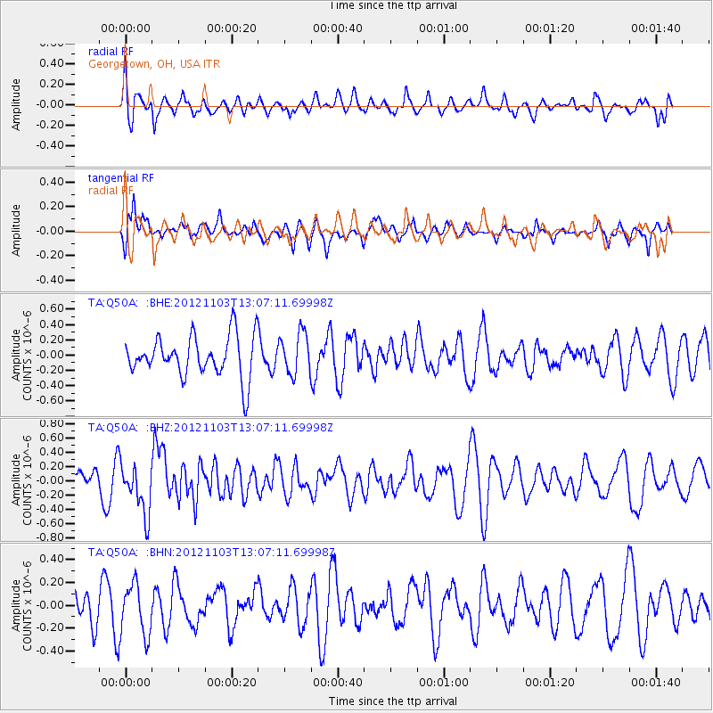
Signal To Noise
| Channel | StoN | STA | LTA |
| TA:Q50A: :BHZ:20121103T13:07:11.69998Z | 1.6471169 | 3.4925128E-7 | 2.1203795E-7 |
| TA:Q50A: :BHN:20121103T13:07:11.69998Z | 1.4198434 | 2.2136318E-7 | 1.5590675E-7 |
| TA:Q50A: :BHE:20121103T13:07:11.69998Z | 1.0245163 | 2.7375182E-7 | 2.6720102E-7 |
| Arrivals |
| Ps | |
| PpPs | |
| PsPs/PpSs | |


