You are here: Home > Network List > CN - Canadian National Seismograph Network Stations List
> Station INK INUVIK, NT > Earthquake Result Viewer
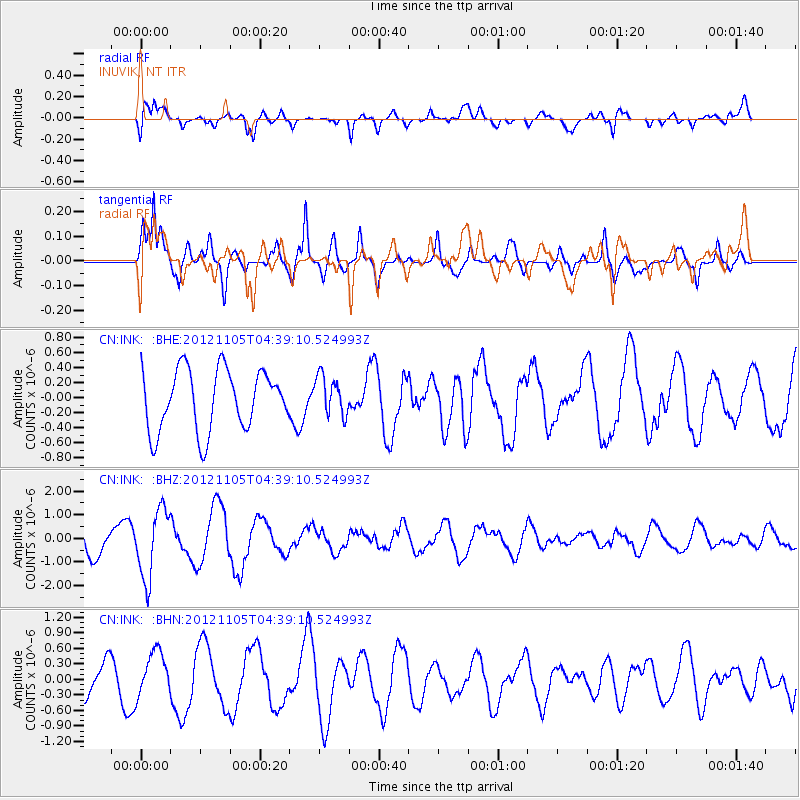
INK INUVIK, NT - Earthquake Result Viewer
*The percent match for this event was below the threshold and hence no stack was calculated.
| Earthquake location: |
Off East Coast Of Honshu, Japan |
| Earthquake latitude/longitude: |
37.8/143.6 |
| Earthquake time(UTC): |
2012/11/05 (310) 04:30:26 GMT |
| Earthquake Depth: |
19 km |
| Earthquake Magnitude: |
5.7 MB, 5.2 MS, 5.6 MW, 5.6 MW |
| Earthquake Catalog/Contributor: |
WHDF/NEIC |
|
| Network: |
CN Canadian National Seismograph Network |
| Station: |
INK INUVIK, NT |
| Lat/Lon: |
68.31 N/133.53 W |
| Elevation: |
44 m |
|
| Distance: |
52.9 deg |
| Az: |
27.546 deg |
| Baz: |
279.781 deg |
| Ray Param: |
$rayparam |
*The percent match for this event was below the threshold and hence was not used in the summary stack. |
|
| Radial Match: |
70.30776 % |
| Radial Bump: |
400 |
| Transverse Match: |
83.2691 % |
| Transverse Bump: |
400 |
| SOD ConfigId: |
486604 |
| Insert Time: |
2013-03-08 04:21:52.417 +0000 |
| GWidth: |
2.5 |
| Max Bumps: |
400 |
| Tol: |
0.001 |
|
Signal To Noise
| Channel | StoN | STA | LTA |
| CN:INK: :BHZ:20121105T04:39:10.524993Z | 2.952027 | 1.4516294E-6 | 4.9173985E-7 |
| CN:INK: :BHN:20121105T04:39:10.524993Z | 1.574728 | 4.2009637E-7 | 2.6677395E-7 |
| CN:INK: :BHE:20121105T04:39:10.524993Z | 0.6405289 | 2.581548E-7 | 4.030338E-7 |
| Arrivals |
| Ps | |
| PpPs | |
| PsPs/PpSs | |


