You are here: Home > Network List > TA - USArray Transportable Network (new EarthScope stations) Stations List
> Station R11A Troy Canyon, Currant, NV, USA > Earthquake Result Viewer
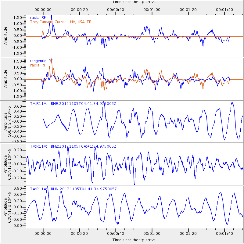
R11A Troy Canyon, Currant, NV, USA - Earthquake Result Viewer
*The percent match for this event was below the threshold and hence no stack was calculated.
| Earthquake location: |
Off East Coast Of Honshu, Japan |
| Earthquake latitude/longitude: |
37.8/143.6 |
| Earthquake time(UTC): |
2012/11/05 (310) 04:30:26 GMT |
| Earthquake Depth: |
19 km |
| Earthquake Magnitude: |
5.7 MB, 5.2 MS, 5.6 MW, 5.6 MW |
| Earthquake Catalog/Contributor: |
WHDF/NEIC |
|
| Network: |
TA USArray Transportable Network (new EarthScope stations) |
| Station: |
R11A Troy Canyon, Currant, NV, USA |
| Lat/Lon: |
38.35 N/115.59 W |
| Elevation: |
1756 m |
|
| Distance: |
74.9 deg |
| Az: |
53.12 deg |
| Baz: |
306.296 deg |
| Ray Param: |
$rayparam |
*The percent match for this event was below the threshold and hence was not used in the summary stack. |
|
| Radial Match: |
72.18512 % |
| Radial Bump: |
400 |
| Transverse Match: |
61.251347 % |
| Transverse Bump: |
366 |
| SOD ConfigId: |
486604 |
| Insert Time: |
2013-03-08 04:27:28.481 +0000 |
| GWidth: |
2.5 |
| Max Bumps: |
400 |
| Tol: |
0.001 |
|
Signal To Noise
| Channel | StoN | STA | LTA |
| TA:R11A: :BHZ:20121105T04:41:34.975005Z | 0.45843458 | 4.8355812E-8 | 1.0548029E-7 |
| TA:R11A: :BHN:20121105T04:41:34.975005Z | 3.0046575 | 4.998886E-7 | 1.6637125E-7 |
| TA:R11A: :BHE:20121105T04:41:34.975005Z | 1.4627991 | 3.9120877E-7 | 2.6743848E-7 |
| Arrivals |
| Ps | |
| PpPs | |
| PsPs/PpSs | |


