You are here: Home > Network List > TA - USArray Transportable Network (new EarthScope stations) Stations List
> Station P47A Martinsville, IN, USA > Earthquake Result Viewer
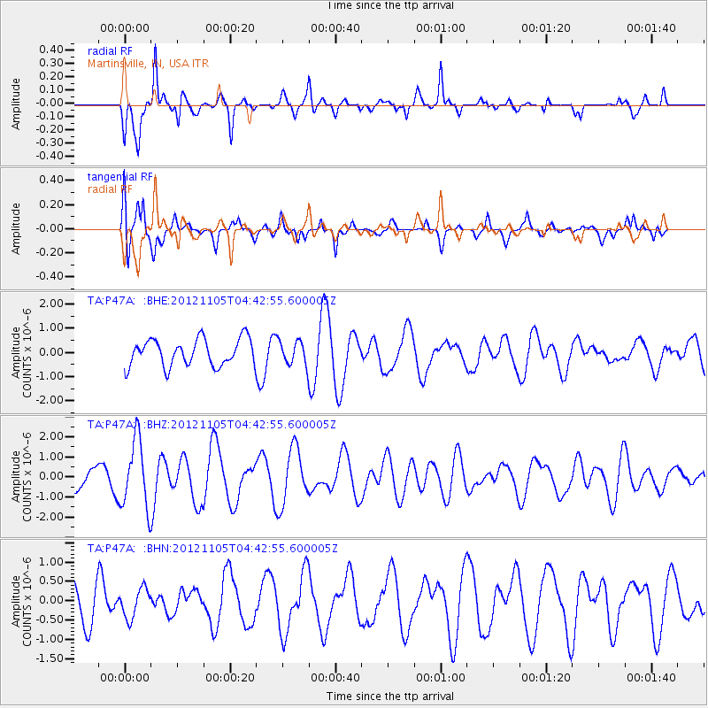
P47A Martinsville, IN, USA - Earthquake Result Viewer
*The percent match for this event was below the threshold and hence no stack was calculated.
| Earthquake location: |
Off East Coast Of Honshu, Japan |
| Earthquake latitude/longitude: |
37.8/143.6 |
| Earthquake time(UTC): |
2012/11/05 (310) 04:30:26 GMT |
| Earthquake Depth: |
19 km |
| Earthquake Magnitude: |
5.7 MB, 5.2 MS, 5.6 MW, 5.6 MW |
| Earthquake Catalog/Contributor: |
WHDF/NEIC |
|
| Network: |
TA USArray Transportable Network (new EarthScope stations) |
| Station: |
P47A Martinsville, IN, USA |
| Lat/Lon: |
39.49 N/86.27 W |
| Elevation: |
246 m |
|
| Distance: |
90.5 deg |
| Az: |
36.284 deg |
| Baz: |
322.711 deg |
| Ray Param: |
$rayparam |
*The percent match for this event was below the threshold and hence was not used in the summary stack. |
|
| Radial Match: |
83.8299 % |
| Radial Bump: |
399 |
| Transverse Match: |
78.526855 % |
| Transverse Bump: |
400 |
| SOD ConfigId: |
486604 |
| Insert Time: |
2013-03-08 04:31:42.665 +0000 |
| GWidth: |
2.5 |
| Max Bumps: |
400 |
| Tol: |
0.001 |
|
Signal To Noise
| Channel | StoN | STA | LTA |
| TA:P47A: :BHZ:20121105T04:42:55.600005Z | 2.9566994 | 1.6974562E-6 | 5.741051E-7 |
| TA:P47A: :BHN:20121105T04:42:55.600005Z | 0.81755364 | 3.8293663E-7 | 4.683933E-7 |
| TA:P47A: :BHE:20121105T04:42:55.600005Z | 0.89638364 | 4.9992065E-7 | 5.5770835E-7 |
| Arrivals |
| Ps | |
| PpPs | |
| PsPs/PpSs | |


