You are here: Home > Network List > TA - USArray Transportable Network (new EarthScope stations) Stations List
> Station T47A Sharon Grove, KY, USA > Earthquake Result Viewer
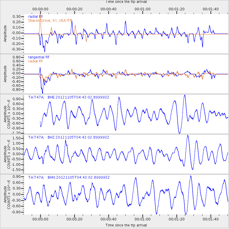
T47A Sharon Grove, KY, USA - Earthquake Result Viewer
*The percent match for this event was below the threshold and hence no stack was calculated.
| Earthquake location: |
Off East Coast Of Honshu, Japan |
| Earthquake latitude/longitude: |
37.8/143.6 |
| Earthquake time(UTC): |
2012/11/05 (310) 04:30:26 GMT |
| Earthquake Depth: |
19 km |
| Earthquake Magnitude: |
5.7 MB, 5.2 MS, 5.6 MW, 5.6 MW |
| Earthquake Catalog/Contributor: |
WHDF/NEIC |
|
| Network: |
TA USArray Transportable Network (new EarthScope stations) |
| Station: |
T47A Sharon Grove, KY, USA |
| Lat/Lon: |
36.99 N/87.11 W |
| Elevation: |
217 m |
|
| Distance: |
92.1 deg |
| Az: |
38.327 deg |
| Baz: |
322.15 deg |
| Ray Param: |
$rayparam |
*The percent match for this event was below the threshold and hence was not used in the summary stack. |
|
| Radial Match: |
50.668106 % |
| Radial Bump: |
400 |
| Transverse Match: |
74.02446 % |
| Transverse Bump: |
400 |
| SOD ConfigId: |
486604 |
| Insert Time: |
2013-03-08 04:31:59.472 +0000 |
| GWidth: |
2.5 |
| Max Bumps: |
400 |
| Tol: |
0.001 |
|
Signal To Noise
| Channel | StoN | STA | LTA |
| TA:T47A: :BHZ:20121105T04:43:02.899993Z | 1.310199 | 4.7167285E-7 | 3.600009E-7 |
| TA:T47A: :BHN:20121105T04:43:02.899993Z | 1.2329235 | 3.8266018E-7 | 3.1036814E-7 |
| TA:T47A: :BHE:20121105T04:43:02.899993Z | 1.2604414 | 5.2631634E-7 | 4.175651E-7 |
| Arrivals |
| Ps | |
| PpPs | |
| PsPs/PpSs | |


