You are here: Home > Network List > CI - Caltech Regional Seismic Network Stations List
> Station EDW2 EDW2, Mojave, CA, USA > Earthquake Result Viewer
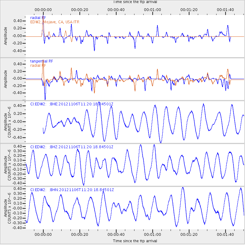
EDW2 EDW2, Mojave, CA, USA - Earthquake Result Viewer
*The percent match for this event was below the threshold and hence no stack was calculated.
| Earthquake location: |
Southeast Of Easter Island |
| Earthquake latitude/longitude: |
-35.5/-104.8 |
| Earthquake time(UTC): |
2012/11/06 (311) 11:09:31 GMT |
| Earthquake Depth: |
10 km |
| Earthquake Magnitude: |
5.5 MW, 4.9 MS, 4.7 MB, 5.6 MW |
| Earthquake Catalog/Contributor: |
WHDF/NEIC |
|
| Network: |
CI Caltech Regional Seismic Network |
| Station: |
EDW2 EDW2, Mojave, CA, USA |
| Lat/Lon: |
34.88 N/117.99 W |
| Elevation: |
772 m |
|
| Distance: |
71.1 deg |
| Az: |
348.557 deg |
| Baz: |
168.639 deg |
| Ray Param: |
$rayparam |
*The percent match for this event was below the threshold and hence was not used in the summary stack. |
|
| Radial Match: |
68.85713 % |
| Radial Bump: |
352 |
| Transverse Match: |
38.60343 % |
| Transverse Bump: |
317 |
| SOD ConfigId: |
486604 |
| Insert Time: |
2013-03-08 05:04:30.984 +0000 |
| GWidth: |
2.5 |
| Max Bumps: |
400 |
| Tol: |
0.001 |
|
Signal To Noise
| Channel | StoN | STA | LTA |
| CI:EDW2: :BHZ:20121106T11:20:18.84501Z | 0.8339239 | 1.6181922E-7 | 1.9404555E-7 |
| CI:EDW2: :BHN:20121106T11:20:18.84501Z | 0.85546255 | 1.39561E-7 | 1.6314098E-7 |
| CI:EDW2: :BHE:20121106T11:20:18.84501Z | 2.7627017 | 3.5599214E-7 | 1.2885653E-7 |
| Arrivals |
| Ps | |
| PpPs | |
| PsPs/PpSs | |


