You are here: Home > Network List > CZ - Czech Regional Seismic Network Stations List
> Station DPC Dobruska, Czech Republic > Earthquake Result Viewer
DPC Dobruska, Czech Republic - Earthquake Result Viewer
| Earthquake location: |
Kuril Islands |
| Earthquake latitude/longitude: |
45.7/149.2 |
| Earthquake time(UTC): |
1994/10/16 (289) 05:10:03 GMT |
| Earthquake Depth: |
139 km |
| Earthquake Magnitude: |
6.3 MB, 6.8 UNKNOWN, 6.7 MW |
| Earthquake Catalog/Contributor: |
WHDF/NEIC |
|
| Network: |
CZ Czech Regional Seismic Network |
| Station: |
DPC Dobruska, Czech Republic |
| Lat/Lon: |
50.36 N/16.41 E |
| Elevation: |
760 m |
|
| Distance: |
75.9 deg |
| Az: |
331.024 deg |
| Baz: |
31.983 deg |
| Ray Param: |
0.051002152 |
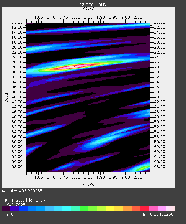
| Estimated Moho Depth: |
27.5 km |
| Estimated Crust Vp/Vs: |
1.79 |
| Assumed Crust Vp: |
6.194 km/s |
| Estimated Crust Vs: |
3.456 km/s |
| Estimated Crust Poisson's Ratio: |
0.27 |
|
| Radial Match: |
96.229355 % |
| Radial Bump: |
265 |
| Transverse Match: |
86.4892 % |
| Transverse Bump: |
400 |
| SOD ConfigId: |
17000 |
| Insert Time: |
2010-02-27 01:12:03.271 +0000 |
| GWidth: |
2.5 |
| Max Bumps: |
400 |
| Tol: |
0.001 |
|
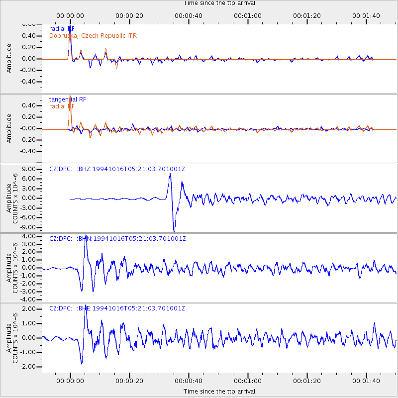
Signal To Noise
| Channel | StoN | STA | LTA |
| CZ:DPC: :BHN:19941016T05:21:03.701001Z | 17.193953 | 1.1903003E-6 | 6.922784E-8 |
| CZ:DPC: :BHE:19941016T05:21:03.701001Z | 7.593115 | 6.9207033E-7 | 9.114445E-8 |
| CZ:DPC: :BHZ:19941016T05:21:03.701001Z | 23.00801 | 3.1775191E-6 | 1.381049E-7 |
| Arrivals |
| Ps | 3.6 SECOND |
| PpPs | 12 SECOND |
| PsPs/PpSs | 16 SECOND |


