You are here: Home > Network List > TA - USArray Transportable Network (new EarthScope stations) Stations List
> Station J04D Umpqua National Forest, Toketee, OR, USA > Earthquake Result Viewer
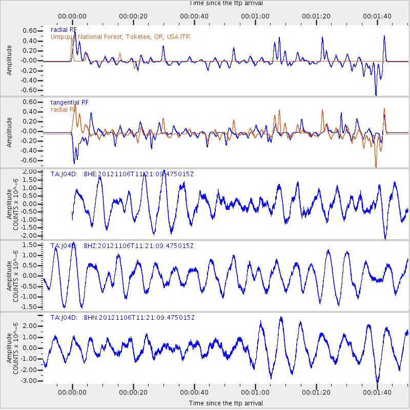
J04D Umpqua National Forest, Toketee, OR, USA - Earthquake Result Viewer
*The percent match for this event was below the threshold and hence no stack was calculated.
| Earthquake location: |
Southeast Of Easter Island |
| Earthquake latitude/longitude: |
-35.5/-104.8 |
| Earthquake time(UTC): |
2012/11/06 (311) 11:09:31 GMT |
| Earthquake Depth: |
10 km |
| Earthquake Magnitude: |
5.5 MW, 4.9 MS, 4.7 MB, 5.6 MW |
| Earthquake Catalog/Contributor: |
WHDF/NEIC |
|
| Network: |
TA USArray Transportable Network (new EarthScope stations) |
| Station: |
J04D Umpqua National Forest, Toketee, OR, USA |
| Lat/Lon: |
43.24 N/122.11 W |
| Elevation: |
1948 m |
|
| Distance: |
79.9 deg |
| Az: |
347.241 deg |
| Baz: |
165.718 deg |
| Ray Param: |
$rayparam |
*The percent match for this event was below the threshold and hence was not used in the summary stack. |
|
| Radial Match: |
58.10594 % |
| Radial Bump: |
400 |
| Transverse Match: |
58.398098 % |
| Transverse Bump: |
400 |
| SOD ConfigId: |
486604 |
| Insert Time: |
2013-03-08 05:08:52.784 +0000 |
| GWidth: |
2.5 |
| Max Bumps: |
400 |
| Tol: |
0.001 |
|
Signal To Noise
| Channel | StoN | STA | LTA |
| TA:J04D: :BHZ:20121106T11:21:09.475015Z | 2.3935962 | 1.0402098E-6 | 4.345803E-7 |
| TA:J04D: :BHN:20121106T11:21:09.475015Z | 1.0933515 | 6.9400335E-7 | 6.347486E-7 |
| TA:J04D: :BHE:20121106T11:21:09.475015Z | 1.5427536 | 1.2760602E-6 | 8.271316E-7 |
| Arrivals |
| Ps | |
| PpPs | |
| PsPs/PpSs | |


