You are here: Home > Network List > CZ - Czech Regional Seismic Network Stations List
> Station DPC Dobruska, Czech Republic > Earthquake Result Viewer
DPC Dobruska, Czech Republic - Earthquake Result Viewer
| Earthquake location: |
Kuril Islands |
| Earthquake latitude/longitude: |
44.6/149.4 |
| Earthquake time(UTC): |
1995/12/03 (337) 18:01:08 GMT |
| Earthquake Depth: |
33 km |
| Earthquake Magnitude: |
6.6 MB, 8.0 MS |
| Earthquake Catalog/Contributor: |
WHDF/NEIC |
|
| Network: |
CZ Czech Regional Seismic Network |
| Station: |
DPC Dobruska, Czech Republic |
| Lat/Lon: |
50.36 N/16.41 E |
| Elevation: |
760 m |
|
| Distance: |
77.0 deg |
| Az: |
331.245 deg |
| Baz: |
32.468 deg |
| Ray Param: |
0.05057456 |
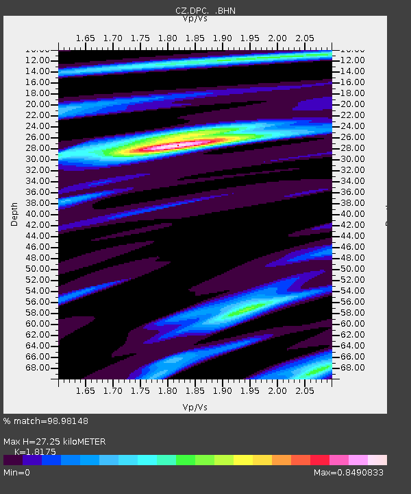
| Estimated Moho Depth: |
27.25 km |
| Estimated Crust Vp/Vs: |
1.82 |
| Assumed Crust Vp: |
6.194 km/s |
| Estimated Crust Vs: |
3.408 km/s |
| Estimated Crust Poisson's Ratio: |
0.28 |
|
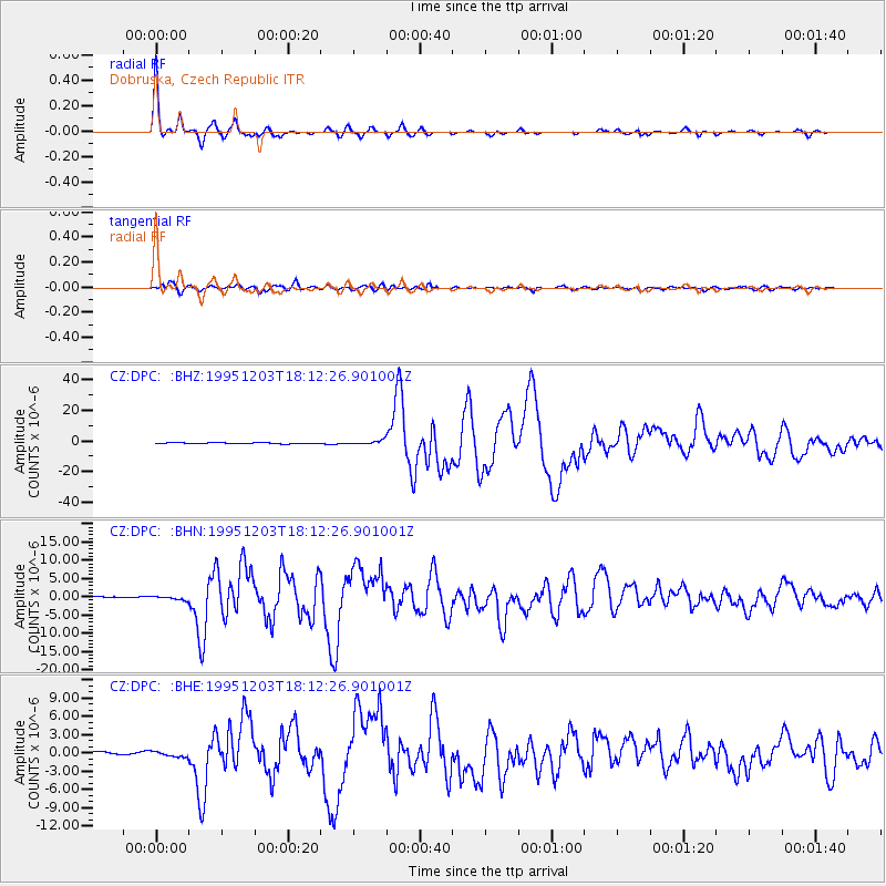
| Radial Match: |
98.98148 % |
| Radial Bump: |
255 |
| Transverse Match: |
93.57876 % |
| Transverse Bump: |
400 |
| SOD ConfigId: |
6273 |
| Insert Time: |
2010-02-27 01:12:13.089 +0000 |
| GWidth: |
2.5 |
| Max Bumps: |
400 |
| Tol: |
0.001 |
|
Signal To Noise
| Channel | StoN | STA | LTA |
| CZ:DPC: :BHN:19951203T18:12:26.901001Z | 3.02699 | 4.985645E-7 | 1.6470635E-7 |
| CZ:DPC: :BHE:19951203T18:12:26.901001Z | 1.4450842 | 4.3735315E-7 | 3.026489E-7 |
| CZ:DPC: :BHZ:19951203T18:12:26.901001Z | 3.7670276 | 1.2662324E-6 | 3.3613568E-7 |
| Arrivals |
| Ps | 3.7 SECOND |
| PpPs | 12 SECOND |
| PsPs/PpSs | 16 SECOND |


