You are here: Home > Network List > G - GEOSCOPE Stations List
> Station INU Inuyama, Japan > Earthquake Result Viewer
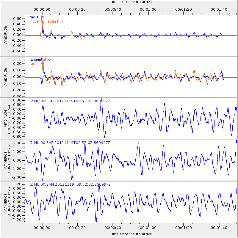
INU Inuyama, Japan - Earthquake Result Viewer
*The percent match for this event was below the threshold and hence no stack was calculated.
| Earthquake location: |
New Britain Region, P.N.G. |
| Earthquake latitude/longitude: |
-5.7/151.6 |
| Earthquake time(UTC): |
2012/11/19 (324) 09:44:34 GMT |
| Earthquake Depth: |
13 km |
| Earthquake Magnitude: |
5.9 MB, 5.9 MS, 6.0 MW, 5.9 MW |
| Earthquake Catalog/Contributor: |
WHDF/NEIC |
|
| Network: |
G GEOSCOPE |
| Station: |
INU Inuyama, Japan |
| Lat/Lon: |
35.35 N/137.03 E |
| Elevation: |
132 m |
|
| Distance: |
43.1 deg |
| Az: |
342.473 deg |
| Baz: |
158.494 deg |
| Ray Param: |
$rayparam |
*The percent match for this event was below the threshold and hence was not used in the summary stack. |
|
| Radial Match: |
63.13676 % |
| Radial Bump: |
400 |
| Transverse Match: |
48.18737 % |
| Transverse Bump: |
371 |
| SOD ConfigId: |
486959 |
| Insert Time: |
2013-03-21 19:22:11.600 +0000 |
| GWidth: |
2.5 |
| Max Bumps: |
400 |
| Tol: |
0.001 |
|
Signal To Noise
| Channel | StoN | STA | LTA |
| G:INU:00:BHZ:20121119T09:52:02.860997Z | 2.1754785 | 1.0245639E-6 | 4.7096026E-7 |
| G:INU:00:BHN:20121119T09:52:02.860997Z | 0.727813 | 2.330841E-7 | 3.2025272E-7 |
| G:INU:00:BHE:20121119T09:52:02.860997Z | 2.1004539 | 4.0951082E-7 | 1.9496302E-7 |
| Arrivals |
| Ps | |
| PpPs | |
| PsPs/PpSs | |


