You are here: Home > Network List > TA - USArray Transportable Network (new EarthScope stations) Stations List
> Station 348A Jackson, AL, USA > Earthquake Result Viewer
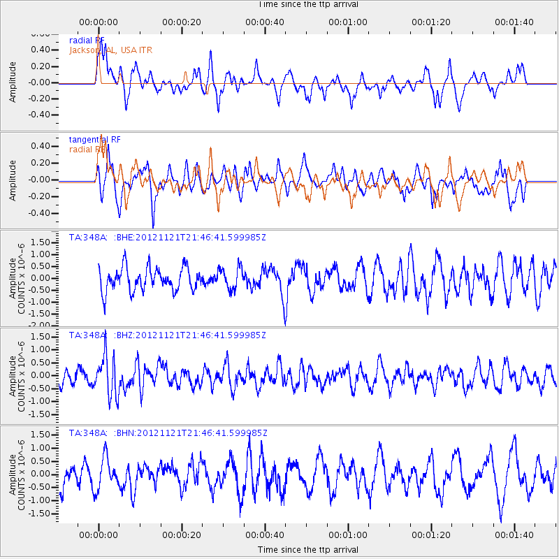
348A Jackson, AL, USA - Earthquake Result Viewer
*The percent match for this event was below the threshold and hence no stack was calculated.
| Earthquake location: |
Near Coast Of Central Chile |
| Earthquake latitude/longitude: |
-33.9/-71.9 |
| Earthquake time(UTC): |
2012/11/21 (326) 21:36:22 GMT |
| Earthquake Depth: |
18 km |
| Earthquake Magnitude: |
5.7 MB, 5.5 MS, 5.9 MW, 5.8 MW |
| Earthquake Catalog/Contributor: |
WHDF/NEIC |
|
| Network: |
TA USArray Transportable Network (new EarthScope stations) |
| Station: |
348A Jackson, AL, USA |
| Lat/Lon: |
31.41 N/87.90 W |
| Elevation: |
57 m |
|
| Distance: |
66.7 deg |
| Az: |
345.105 deg |
| Baz: |
165.525 deg |
| Ray Param: |
$rayparam |
*The percent match for this event was below the threshold and hence was not used in the summary stack. |
|
| Radial Match: |
55.275875 % |
| Radial Bump: |
400 |
| Transverse Match: |
64.45456 % |
| Transverse Bump: |
400 |
| SOD ConfigId: |
486959 |
| Insert Time: |
2013-03-21 19:35:26.619 +0000 |
| GWidth: |
2.5 |
| Max Bumps: |
400 |
| Tol: |
0.001 |
|
Signal To Noise
| Channel | StoN | STA | LTA |
| TA:348A: :BHZ:20121121T21:46:41.599985Z | 2.9741182 | 7.8997675E-7 | 2.6561713E-7 |
| TA:348A: :BHN:20121121T21:46:41.599985Z | 0.99432284 | 6.0552264E-7 | 6.0898E-7 |
| TA:348A: :BHE:20121121T21:46:41.599985Z | 0.96044713 | 4.6591728E-7 | 4.851046E-7 |
| Arrivals |
| Ps | |
| PpPs | |
| PsPs/PpSs | |


