You are here: Home > Network List > TA - USArray Transportable Network (new EarthScope stations) Stations List
> Station Y42A Garnett, Star City, AR, USA > Earthquake Result Viewer
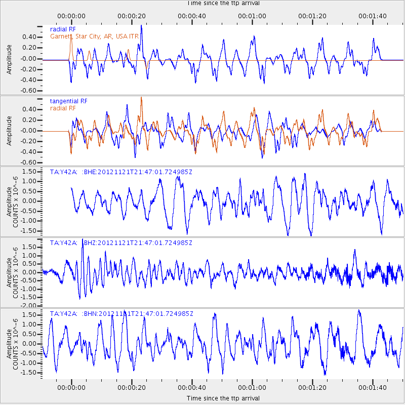
Y42A Garnett, Star City, AR, USA - Earthquake Result Viewer
*The percent match for this event was below the threshold and hence no stack was calculated.
| Earthquake location: |
Near Coast Of Central Chile |
| Earthquake latitude/longitude: |
-33.9/-71.9 |
| Earthquake time(UTC): |
2012/11/21 (326) 21:36:22 GMT |
| Earthquake Depth: |
18 km |
| Earthquake Magnitude: |
5.7 MB, 5.5 MS, 5.9 MW, 5.8 MW |
| Earthquake Catalog/Contributor: |
WHDF/NEIC |
|
| Network: |
TA USArray Transportable Network (new EarthScope stations) |
| Station: |
Y42A Garnett, Star City, AR, USA |
| Lat/Lon: |
33.84 N/91.79 W |
| Elevation: |
77 m |
|
| Distance: |
70.0 deg |
| Az: |
342.432 deg |
| Baz: |
162.453 deg |
| Ray Param: |
$rayparam |
*The percent match for this event was below the threshold and hence was not used in the summary stack. |
|
| Radial Match: |
53.99994 % |
| Radial Bump: |
369 |
| Transverse Match: |
59.875694 % |
| Transverse Bump: |
364 |
| SOD ConfigId: |
486959 |
| Insert Time: |
2013-03-21 19:36:05.906 +0000 |
| GWidth: |
2.5 |
| Max Bumps: |
400 |
| Tol: |
0.001 |
|
Signal To Noise
| Channel | StoN | STA | LTA |
| TA:Y42A: :BHZ:20121121T21:47:01.724985Z | 2.3867617 | 8.6643064E-7 | 3.6301515E-7 |
| TA:Y42A: :BHN:20121121T21:47:01.724985Z | 0.40242922 | 3.0857606E-7 | 7.667835E-7 |
| TA:Y42A: :BHE:20121121T21:47:01.724985Z | 2.425764 | 9.296494E-7 | 3.8323984E-7 |
| Arrivals |
| Ps | |
| PpPs | |
| PsPs/PpSs | |


