You are here: Home > Network List > TA - USArray Transportable Network (new EarthScope stations) Stations List
> Station N42A Yates City, IL, USA > Earthquake Result Viewer
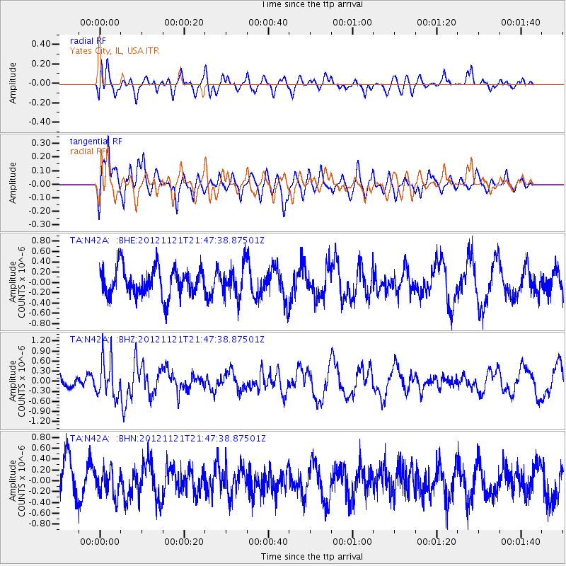
N42A Yates City, IL, USA - Earthquake Result Viewer
*The percent match for this event was below the threshold and hence no stack was calculated.
| Earthquake location: |
Near Coast Of Central Chile |
| Earthquake latitude/longitude: |
-33.9/-71.9 |
| Earthquake time(UTC): |
2012/11/21 (326) 21:36:22 GMT |
| Earthquake Depth: |
18 km |
| Earthquake Magnitude: |
5.7 MB, 5.5 MS, 5.9 MW, 5.8 MW |
| Earthquake Catalog/Contributor: |
WHDF/NEIC |
|
| Network: |
TA USArray Transportable Network (new EarthScope stations) |
| Station: |
N42A Yates City, IL, USA |
| Lat/Lon: |
40.83 N/90.03 W |
| Elevation: |
205 m |
|
| Distance: |
76.3 deg |
| Az: |
345.904 deg |
| Baz: |
164.524 deg |
| Ray Param: |
$rayparam |
*The percent match for this event was below the threshold and hence was not used in the summary stack. |
|
| Radial Match: |
59.937046 % |
| Radial Bump: |
400 |
| Transverse Match: |
71.06885 % |
| Transverse Bump: |
400 |
| SOD ConfigId: |
486959 |
| Insert Time: |
2013-03-21 19:41:02.355 +0000 |
| GWidth: |
2.5 |
| Max Bumps: |
400 |
| Tol: |
0.001 |
|
Signal To Noise
| Channel | StoN | STA | LTA |
| TA:N42A: :BHZ:20121121T21:47:38.87501Z | 2.3472207 | 5.474606E-7 | 2.332378E-7 |
| TA:N42A: :BHN:20121121T21:47:38.87501Z | 0.811231 | 2.4504578E-7 | 3.020666E-7 |
| TA:N42A: :BHE:20121121T21:47:38.87501Z | 1.1086057 | 3.0192666E-7 | 2.7234807E-7 |
| Arrivals |
| Ps | |
| PpPs | |
| PsPs/PpSs | |


