You are here: Home > Network List > TA - USArray Transportable Network (new EarthScope stations) Stations List
> Station N46A Monticello, IN, USA > Earthquake Result Viewer
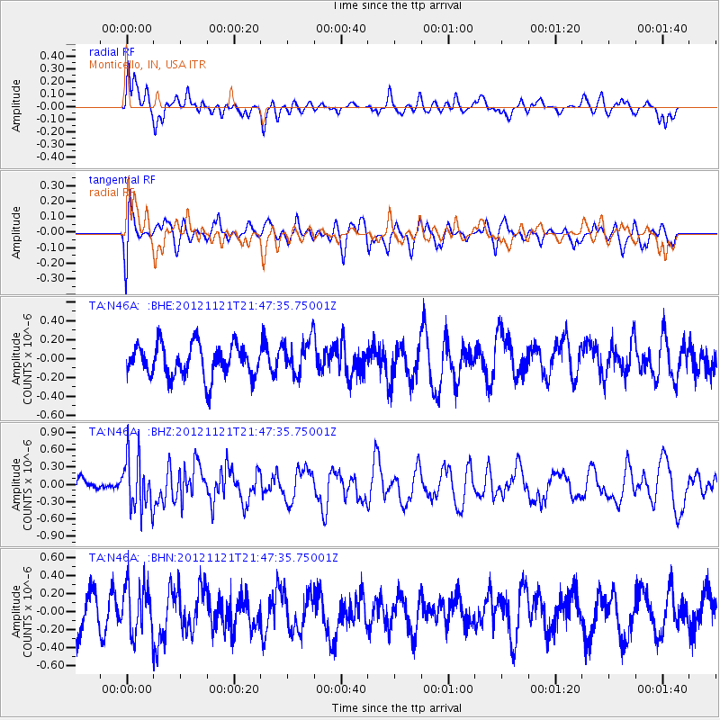
N46A Monticello, IN, USA - Earthquake Result Viewer
*The percent match for this event was below the threshold and hence no stack was calculated.
| Earthquake location: |
Near Coast Of Central Chile |
| Earthquake latitude/longitude: |
-33.9/-71.9 |
| Earthquake time(UTC): |
2012/11/21 (326) 21:36:22 GMT |
| Earthquake Depth: |
18 km |
| Earthquake Magnitude: |
5.7 MB, 5.5 MS, 5.9 MW, 5.8 MW |
| Earthquake Catalog/Contributor: |
WHDF/NEIC |
|
| Network: |
TA USArray Transportable Network (new EarthScope stations) |
| Station: |
N46A Monticello, IN, USA |
| Lat/Lon: |
40.89 N/86.74 W |
| Elevation: |
209 m |
|
| Distance: |
75.7 deg |
| Az: |
348.421 deg |
| Baz: |
167.284 deg |
| Ray Param: |
$rayparam |
*The percent match for this event was below the threshold and hence was not used in the summary stack. |
|
| Radial Match: |
60.226826 % |
| Radial Bump: |
400 |
| Transverse Match: |
56.57535 % |
| Transverse Bump: |
400 |
| SOD ConfigId: |
486959 |
| Insert Time: |
2013-03-21 19:41:51.666 +0000 |
| GWidth: |
2.5 |
| Max Bumps: |
400 |
| Tol: |
0.001 |
|
Signal To Noise
| Channel | StoN | STA | LTA |
| TA:N46A: :BHZ:20121121T21:47:35.75001Z | 2.816382 | 4.6155537E-7 | 1.6388238E-7 |
| TA:N46A: :BHN:20121121T21:47:35.75001Z | 1.2324331 | 2.789014E-7 | 2.2630148E-7 |
| TA:N46A: :BHE:20121121T21:47:35.75001Z | 1.0881393 | 1.8671942E-7 | 1.7159515E-7 |
| Arrivals |
| Ps | |
| PpPs | |
| PsPs/PpSs | |


