You are here: Home > Network List > TA - USArray Transportable Network (new EarthScope stations) Stations List
> Station R49A Shelbyville, KY, USA > Earthquake Result Viewer
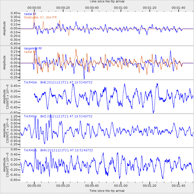
R49A Shelbyville, KY, USA - Earthquake Result Viewer
*The percent match for this event was below the threshold and hence no stack was calculated.
| Earthquake location: |
Near Coast Of Central Chile |
| Earthquake latitude/longitude: |
-33.9/-71.9 |
| Earthquake time(UTC): |
2012/11/21 (326) 21:36:22 GMT |
| Earthquake Depth: |
18 km |
| Earthquake Magnitude: |
5.7 MB, 5.5 MS, 5.9 MW, 5.8 MW |
| Earthquake Catalog/Contributor: |
WHDF/NEIC |
|
| Network: |
TA USArray Transportable Network (new EarthScope stations) |
| Station: |
R49A Shelbyville, KY, USA |
| Lat/Lon: |
38.29 N/85.17 W |
| Elevation: |
251 m |
|
| Distance: |
72.9 deg |
| Az: |
349.081 deg |
| Baz: |
168.456 deg |
| Ray Param: |
$rayparam |
*The percent match for this event was below the threshold and hence was not used in the summary stack. |
|
| Radial Match: |
58.979336 % |
| Radial Bump: |
400 |
| Transverse Match: |
72.96384 % |
| Transverse Bump: |
400 |
| SOD ConfigId: |
486959 |
| Insert Time: |
2013-03-21 19:48:53.196 +0000 |
| GWidth: |
2.5 |
| Max Bumps: |
400 |
| Tol: |
0.001 |
|
Signal To Noise
| Channel | StoN | STA | LTA |
| TA:R49A: :BHZ:20121121T21:47:19.524973Z | 2.5933218 | 5.21499E-7 | 2.0109303E-7 |
| TA:R49A: :BHN:20121121T21:47:19.524973Z | 1.5411993 | 2.3602642E-7 | 1.5314464E-7 |
| TA:R49A: :BHE:20121121T21:47:19.524973Z | 1.139348 | 1.7424203E-7 | 1.5293135E-7 |
| Arrivals |
| Ps | |
| PpPs | |
| PsPs/PpSs | |


