You are here: Home > Network List > CZ - Czech Regional Seismic Network Stations List
> Station DPC Dobruska, Czech Republic > Earthquake Result Viewer
DPC Dobruska, Czech Republic - Earthquake Result Viewer
| Earthquake location: |
Kuril Islands |
| Earthquake latitude/longitude: |
44.3/149.8 |
| Earthquake time(UTC): |
1995/12/10 (344) 22:23:14 GMT |
| Earthquake Depth: |
33 km |
| Earthquake Magnitude: |
5.6 MB, 6.4 MS |
| Earthquake Catalog/Contributor: |
WHDF/NEIC |
|
| Network: |
CZ Czech Regional Seismic Network |
| Station: |
DPC Dobruska, Czech Republic |
| Lat/Lon: |
50.36 N/16.41 E |
| Elevation: |
760 m |
|
| Distance: |
77.3 deg |
| Az: |
331.498 deg |
| Baz: |
32.321 deg |
| Ray Param: |
0.050340615 |
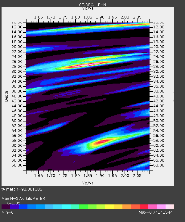
| Estimated Moho Depth: |
27.0 km |
| Estimated Crust Vp/Vs: |
1.85 |
| Assumed Crust Vp: |
6.194 km/s |
| Estimated Crust Vs: |
3.348 km/s |
| Estimated Crust Poisson's Ratio: |
0.29 |
|
| Radial Match: |
93.361305 % |
| Radial Bump: |
264 |
| Transverse Match: |
76.25771 % |
| Transverse Bump: |
392 |
| SOD ConfigId: |
6273 |
| Insert Time: |
2010-02-27 01:13:07.843 +0000 |
| GWidth: |
2.5 |
| Max Bumps: |
400 |
| Tol: |
0.001 |
|
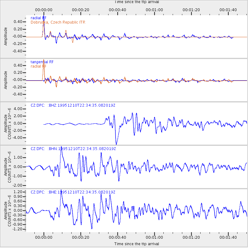
Signal To Noise
| Channel | StoN | STA | LTA |
| CZ:DPC: :BHN:19951210T22:34:35.082019Z | 1.2828832 | 2.0476615E-7 | 1.5961403E-7 |
| CZ:DPC: :BHE:19951210T22:34:35.082019Z | 1.9156369 | 1.8301753E-7 | 9.553874E-8 |
| CZ:DPC: :BHZ:19951210T22:34:35.082019Z | 5.1716065 | 6.615036E-7 | 1.2791065E-7 |
| Arrivals |
| Ps | 3.8 SECOND |
| PpPs | 12 SECOND |
| PsPs/PpSs | 16 SECOND |


