You are here: Home > Network List > TA - USArray Transportable Network (new EarthScope stations) Stations List
> Station L48A N Adams, MI, USA > Earthquake Result Viewer
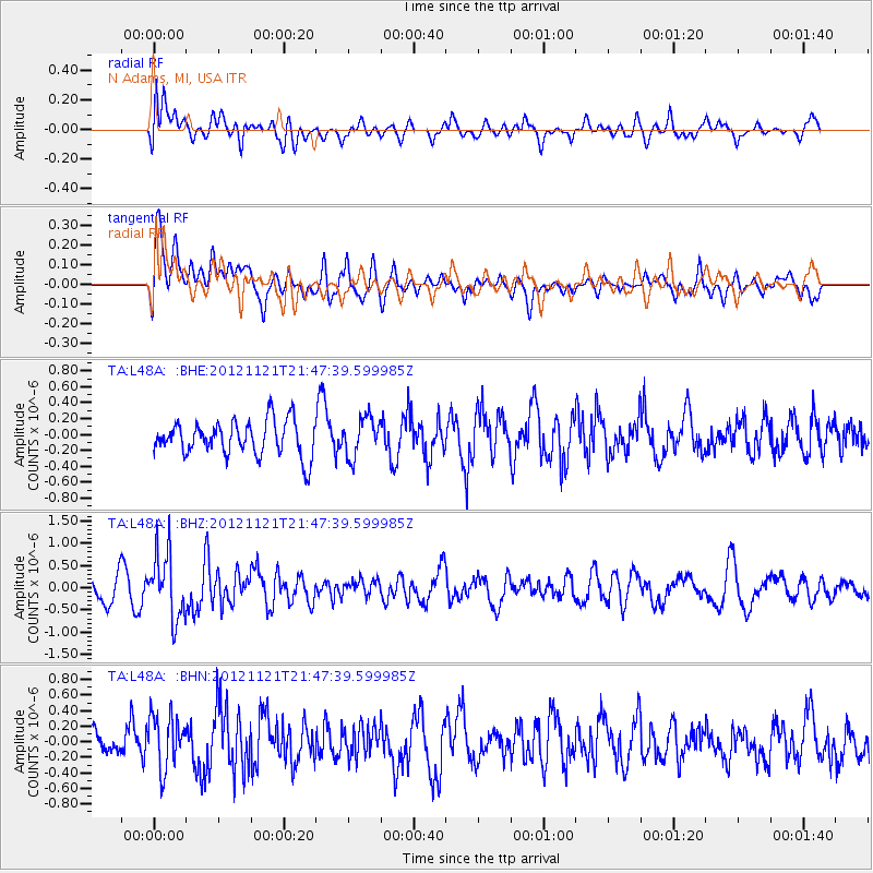
L48A N Adams, MI, USA - Earthquake Result Viewer
*The percent match for this event was below the threshold and hence no stack was calculated.
| Earthquake location: |
Near Coast Of Central Chile |
| Earthquake latitude/longitude: |
-33.9/-71.9 |
| Earthquake time(UTC): |
2012/11/21 (326) 21:36:22 GMT |
| Earthquake Depth: |
18 km |
| Earthquake Magnitude: |
5.7 MB, 5.5 MS, 5.9 MW, 5.8 MW |
| Earthquake Catalog/Contributor: |
WHDF/NEIC |
|
| Network: |
TA USArray Transportable Network (new EarthScope stations) |
| Station: |
L48A N Adams, MI, USA |
| Lat/Lon: |
41.94 N/84.43 W |
| Elevation: |
369 m |
|
| Distance: |
76.4 deg |
| Az: |
350.388 deg |
| Baz: |
169.276 deg |
| Ray Param: |
$rayparam |
*The percent match for this event was below the threshold and hence was not used in the summary stack. |
|
| Radial Match: |
54.507195 % |
| Radial Bump: |
400 |
| Transverse Match: |
67.550255 % |
| Transverse Bump: |
400 |
| SOD ConfigId: |
486959 |
| Insert Time: |
2013-03-21 19:50:16.044 +0000 |
| GWidth: |
2.5 |
| Max Bumps: |
400 |
| Tol: |
0.001 |
|
Signal To Noise
| Channel | StoN | STA | LTA |
| TA:L48A: :BHZ:20121121T21:47:39.599985Z | 2.926298 | 7.342368E-7 | 2.5090978E-7 |
| TA:L48A: :BHN:20121121T21:47:39.599985Z | 1.7043575 | 3.4695273E-7 | 2.0356804E-7 |
| TA:L48A: :BHE:20121121T21:47:39.599985Z | 1.1159378 | 2.4269085E-7 | 2.1747702E-7 |
| Arrivals |
| Ps | |
| PpPs | |
| PsPs/PpSs | |


