You are here: Home > Network List > UW - Pacific Northwest Regional Seismic Network Stations List
> Station UMAT Pilot Rock, OR, USA > Earthquake Result Viewer
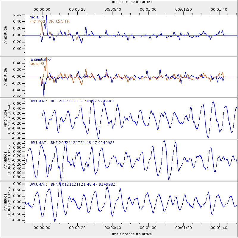
UMAT Pilot Rock, OR, USA - Earthquake Result Viewer
*The percent match for this event was below the threshold and hence no stack was calculated.
| Earthquake location: |
Near Coast Of Central Chile |
| Earthquake latitude/longitude: |
-33.9/-71.9 |
| Earthquake time(UTC): |
2012/11/21 (326) 21:36:22 GMT |
| Earthquake Depth: |
18 km |
| Earthquake Magnitude: |
5.7 MB, 5.5 MS, 5.9 MW, 5.8 MW |
| Earthquake Catalog/Contributor: |
WHDF/NEIC |
|
| Network: |
UW Pacific Northwest Regional Seismic Network |
| Station: |
UMAT Pilot Rock, OR, USA |
| Lat/Lon: |
45.29 N/118.96 W |
| Elevation: |
1318 m |
|
| Distance: |
89.7 deg |
| Az: |
328.866 deg |
| Baz: |
142.487 deg |
| Ray Param: |
$rayparam |
*The percent match for this event was below the threshold and hence was not used in the summary stack. |
|
| Radial Match: |
68.83461 % |
| Radial Bump: |
370 |
| Transverse Match: |
76.079094 % |
| Transverse Bump: |
329 |
| SOD ConfigId: |
486959 |
| Insert Time: |
2013-03-21 19:52:51.272 +0000 |
| GWidth: |
2.5 |
| Max Bumps: |
400 |
| Tol: |
0.001 |
|
Signal To Noise
| Channel | StoN | STA | LTA |
| UW:UMAT: :BHZ:20121121T21:48:47.924998Z | 1.5631443 | 5.100696E-7 | 3.2630996E-7 |
| UW:UMAT: :BHN:20121121T21:48:47.924998Z | 1.6812164 | 5.192803E-7 | 3.088718E-7 |
| UW:UMAT: :BHE:20121121T21:48:47.924998Z | 1.8999135 | 4.6712736E-7 | 2.458677E-7 |
| Arrivals |
| Ps | |
| PpPs | |
| PsPs/PpSs | |


