You are here: Home > Network List > CI - Caltech Regional Seismic Network Stations List
> Station MPM Manuel Prospect Mine, California, USA > Earthquake Result Viewer
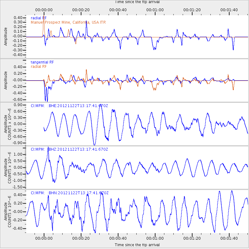
MPM Manuel Prospect Mine, California, USA - Earthquake Result Viewer
*The percent match for this event was below the threshold and hence no stack was calculated.
| Earthquake location: |
Salta Province, Argentina |
| Earthquake latitude/longitude: |
-22.7/-63.6 |
| Earthquake time(UTC): |
2012/11/22 (327) 13:07:10 GMT |
| Earthquake Depth: |
517 km |
| Earthquake Magnitude: |
5.6 MB, 5.9 MW, 6.0 MW |
| Earthquake Catalog/Contributor: |
WHDF/NEIC |
|
| Network: |
CI Caltech Regional Seismic Network |
| Station: |
MPM Manuel Prospect Mine, California, USA |
| Lat/Lon: |
36.06 N/117.49 W |
| Elevation: |
185 m |
|
| Distance: |
77.6 deg |
| Az: |
317.887 deg |
| Baz: |
130.181 deg |
| Ray Param: |
$rayparam |
*The percent match for this event was below the threshold and hence was not used in the summary stack. |
|
| Radial Match: |
57.308857 % |
| Radial Bump: |
400 |
| Transverse Match: |
77.015724 % |
| Transverse Bump: |
400 |
| SOD ConfigId: |
486959 |
| Insert Time: |
2013-03-21 19:56:23.121 +0000 |
| GWidth: |
2.5 |
| Max Bumps: |
400 |
| Tol: |
0.001 |
|
Signal To Noise
| Channel | StoN | STA | LTA |
| CI:MPM: :BHZ:20121122T13:17:41.670Z | 2.9836857 | 6.9274756E-7 | 2.3217845E-7 |
| CI:MPM: :BHN:20121122T13:17:41.670Z | 0.7721621 | 2.191027E-7 | 2.837522E-7 |
| CI:MPM: :BHE:20121122T13:17:41.670Z | 1.6947697 | 6.2169534E-7 | 3.6683173E-7 |
| Arrivals |
| Ps | |
| PpPs | |
| PsPs/PpSs | |


