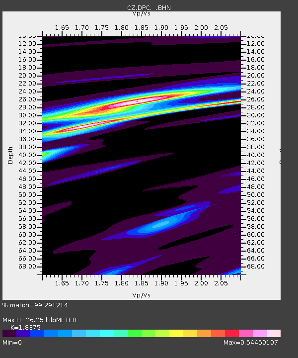
DPC Dobruska, Czech Republic - Earthquake Result Viewer
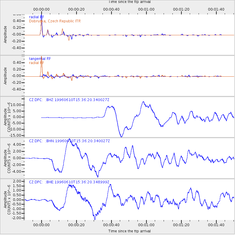
Earthquake location: Andreanof Islands, Aleutian Is.
Earthquake latitude/longitude: 51.5/-176.8
Earthquake time(UTC): 1996/06/10 (162) 15:24:56 GMT
Earthquake Depth: 26 km
Earthquake Magnitude: 5.9 MB, 7.1 MS, 7.2 UNKNOWN, 6.9 MS
Earthquake Catalog/Contributor: WHDF/NEIC
Network: CZ Czech Regional Seismic Network
Station: DPC Dobruska, Czech Republic
Lat/Lon: 50.36 N/16.41 E
Elevation: 760 m
Distance: 77.9 deg
Az: 351.36 deg
Baz: 8.434 deg
Ray Param: 0.049965926
Estimated Moho Depth: 26.25 km
Estimated Crust Vp/Vs: 1.84
Assumed Crust Vp: 6.194 km/s
Estimated Crust Vs: 3.371 km/s
Estimated Crust Poisson's Ratio: 0.29
Radial Match: 99.291214 %
Radial Bump: 150
Transverse Match: 95.35695 %
Transverse Bump: 400
SOD ConfigId: 6273
Insert Time: 2010-02-27 01:13:45.398 +0000
GWidth: 2.5
Max Bumps: 400
Tol: 0.001

Signal To Noise

ChannelStoNSTALTA
CZ:DPC: :BHN:19960610T15:36:20.340027Z1.78554459.561446E-85.3549186E-8
CZ:DPC: :BHE:19960610T15:36:20.348999Z0.98105697.3577446E-87.499814E-8
CZ:DPC: :BHZ:19960610T15:36:20.340027Z3.0487043.146115E-71.0319516E-7
Arrivals
Ps3.6 SECOND
PpPs12 SECOND
PsPs/PpSs15 SECOND