You are here: Home > Network List > TA - USArray Transportable Network (new EarthScope stations) Stations List
> Station MSTX Muleshoe, TX, USA > Earthquake Result Viewer
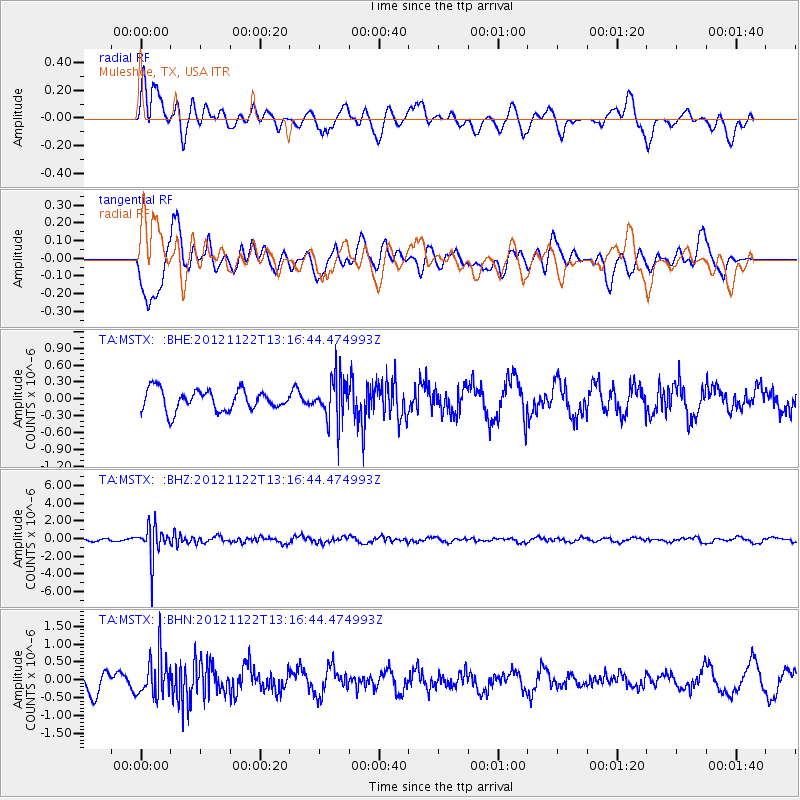
MSTX Muleshoe, TX, USA - Earthquake Result Viewer
*The percent match for this event was below the threshold and hence no stack was calculated.
| Earthquake location: |
Salta Province, Argentina |
| Earthquake latitude/longitude: |
-22.7/-63.6 |
| Earthquake time(UTC): |
2012/11/22 (327) 13:07:10 GMT |
| Earthquake Depth: |
517 km |
| Earthquake Magnitude: |
5.6 MB, 5.9 MW, 6.0 MW |
| Earthquake Catalog/Contributor: |
WHDF/NEIC |
|
| Network: |
TA USArray Transportable Network (new EarthScope stations) |
| Station: |
MSTX Muleshoe, TX, USA |
| Lat/Lon: |
33.97 N/102.77 W |
| Elevation: |
1167 m |
|
| Distance: |
67.6 deg |
| Az: |
325.385 deg |
| Baz: |
140.874 deg |
| Ray Param: |
$rayparam |
*The percent match for this event was below the threshold and hence was not used in the summary stack. |
|
| Radial Match: |
65.03979 % |
| Radial Bump: |
400 |
| Transverse Match: |
71.72915 % |
| Transverse Bump: |
400 |
| SOD ConfigId: |
486959 |
| Insert Time: |
2013-03-21 20:03:49.507 +0000 |
| GWidth: |
2.5 |
| Max Bumps: |
400 |
| Tol: |
0.001 |
|
Signal To Noise
| Channel | StoN | STA | LTA |
| TA:MSTX: :BHZ:20121122T13:16:44.474993Z | 12.254121 | 1.8938515E-6 | 1.5454813E-7 |
| TA:MSTX: :BHN:20121122T13:16:44.474993Z | 2.4677017 | 5.7806926E-7 | 2.3425412E-7 |
| TA:MSTX: :BHE:20121122T13:16:44.474993Z | 2.052168 | 3.783303E-7 | 1.843564E-7 |
| Arrivals |
| Ps | |
| PpPs | |
| PsPs/PpSs | |


