You are here: Home > Network List > TA - USArray Transportable Network (new EarthScope stations) Stations List
> Station Y46A Houston, MS, USA > Earthquake Result Viewer
Y46A Houston, MS, USA - Earthquake Result Viewer
*The percent match for this event was below the threshold and hence no stack was calculated.
| Earthquake location: |
Salta Province, Argentina |
| Earthquake latitude/longitude: |
-22.7/-63.6 |
| Earthquake time(UTC): |
2012/11/22 (327) 13:07:10 GMT |
| Earthquake Depth: |
517 km |
| Earthquake Magnitude: |
5.6 MB, 5.9 MW, 6.0 MW |
| Earthquake Catalog/Contributor: |
WHDF/NEIC |
|
| Network: |
TA USArray Transportable Network (new EarthScope stations) |
| Station: |
Y46A Houston, MS, USA |
| Lat/Lon: |
33.88 N/88.86 W |
| Elevation: |
109 m |
|
| Distance: |
61.2 deg |
| Az: |
336.087 deg |
| Baz: |
153.268 deg |
| Ray Param: |
$rayparam |
*The percent match for this event was below the threshold and hence was not used in the summary stack. |
|
| Radial Match: |
48.1355 % |
| Radial Bump: |
400 |
| Transverse Match: |
59.909523 % |
| Transverse Bump: |
400 |
| SOD ConfigId: |
486959 |
| Insert Time: |
2013-03-21 20:07:48.322 +0000 |
| GWidth: |
2.5 |
| Max Bumps: |
400 |
| Tol: |
0.001 |
|
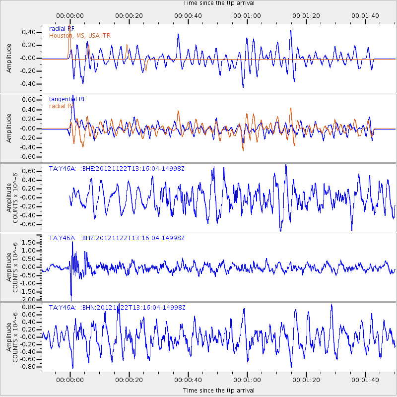
Signal To Noise
| Channel | StoN | STA | LTA |
| TA:Y46A: :BHZ:20121122T13:16:04.14998Z | 3.7536886 | 6.2136905E-7 | 1.6553558E-7 |
| TA:Y46A: :BHN:20121122T13:16:04.14998Z | 1.1029143 | 3.0668613E-7 | 2.7806885E-7 |
| TA:Y46A: :BHE:20121122T13:16:04.14998Z | 1.0815269 | 2.3916215E-7 | 2.2113382E-7 |
| Arrivals |
| Ps | |
| PpPs | |
| PsPs/PpSs | |


