You are here: Home > Network List > TA - USArray Transportable Network (new EarthScope stations) Stations List
> Station V45A Humboldt, TN, USA > Earthquake Result Viewer
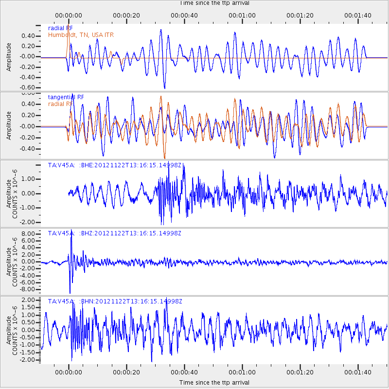
V45A Humboldt, TN, USA - Earthquake Result Viewer
*The percent match for this event was below the threshold and hence no stack was calculated.
| Earthquake location: |
Salta Province, Argentina |
| Earthquake latitude/longitude: |
-22.7/-63.6 |
| Earthquake time(UTC): |
2012/11/22 (327) 13:07:10 GMT |
| Earthquake Depth: |
517 km |
| Earthquake Magnitude: |
5.6 MB, 5.9 MW, 6.0 MW |
| Earthquake Catalog/Contributor: |
WHDF/NEIC |
|
| Network: |
TA USArray Transportable Network (new EarthScope stations) |
| Station: |
V45A Humboldt, TN, USA |
| Lat/Lon: |
35.74 N/88.96 W |
| Elevation: |
126 m |
|
| Distance: |
62.9 deg |
| Az: |
336.941 deg |
| Baz: |
153.61 deg |
| Ray Param: |
$rayparam |
*The percent match for this event was below the threshold and hence was not used in the summary stack. |
|
| Radial Match: |
53.74011 % |
| Radial Bump: |
400 |
| Transverse Match: |
63.971516 % |
| Transverse Bump: |
400 |
| SOD ConfigId: |
486959 |
| Insert Time: |
2013-03-21 20:09:10.905 +0000 |
| GWidth: |
2.5 |
| Max Bumps: |
400 |
| Tol: |
0.001 |
|
Signal To Noise
| Channel | StoN | STA | LTA |
| TA:V45A: :BHZ:20121122T13:16:15.14998Z | 13.788798 | 2.9492521E-6 | 2.1388753E-7 |
| TA:V45A: :BHN:20121122T13:16:15.14998Z | 1.8590595 | 9.37718E-7 | 5.044045E-7 |
| TA:V45A: :BHE:20121122T13:16:15.14998Z | 1.8884585 | 8.593313E-7 | 4.550438E-7 |
| Arrivals |
| Ps | |
| PpPs | |
| PsPs/PpSs | |


