You are here: Home > Network List > TA - USArray Transportable Network (new EarthScope stations) Stations List
> Station V43A Jonesboro, AR, USA > Earthquake Result Viewer
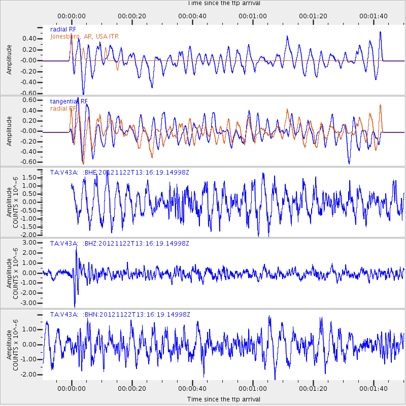
V43A Jonesboro, AR, USA - Earthquake Result Viewer
*The percent match for this event was below the threshold and hence no stack was calculated.
| Earthquake location: |
Salta Province, Argentina |
| Earthquake latitude/longitude: |
-22.7/-63.6 |
| Earthquake time(UTC): |
2012/11/22 (327) 13:07:10 GMT |
| Earthquake Depth: |
517 km |
| Earthquake Magnitude: |
5.6 MB, 5.9 MW, 6.0 MW |
| Earthquake Catalog/Contributor: |
WHDF/NEIC |
|
| Network: |
TA USArray Transportable Network (new EarthScope stations) |
| Station: |
V43A Jonesboro, AR, USA |
| Lat/Lon: |
35.79 N/90.54 W |
| Elevation: |
74 m |
|
| Distance: |
63.6 deg |
| Az: |
335.679 deg |
| Baz: |
152.12 deg |
| Ray Param: |
$rayparam |
*The percent match for this event was below the threshold and hence was not used in the summary stack. |
|
| Radial Match: |
43.98779 % |
| Radial Bump: |
400 |
| Transverse Match: |
57.676674 % |
| Transverse Bump: |
400 |
| SOD ConfigId: |
486959 |
| Insert Time: |
2013-03-21 20:11:09.236 +0000 |
| GWidth: |
2.5 |
| Max Bumps: |
400 |
| Tol: |
0.001 |
|
Signal To Noise
| Channel | StoN | STA | LTA |
| TA:V43A: :BHZ:20121122T13:16:19.14998Z | 4.1138935 | 1.1366359E-6 | 2.76292E-7 |
| TA:V43A: :BHN:20121122T13:16:19.14998Z | 0.7705662 | 5.8871177E-7 | 7.6399897E-7 |
| TA:V43A: :BHE:20121122T13:16:19.14998Z | 0.49758893 | 4.398567E-7 | 8.839761E-7 |
| Arrivals |
| Ps | |
| PpPs | |
| PsPs/PpSs | |


