You are here: Home > Network List > TA - USArray Transportable Network (new EarthScope stations) Stations List
> Station X49A Woodville, AR, USA > Earthquake Result Viewer
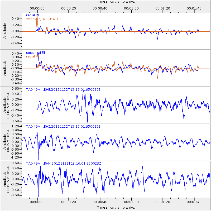
X49A Woodville, AR, USA - Earthquake Result Viewer
*The percent match for this event was below the threshold and hence no stack was calculated.
| Earthquake location: |
Salta Province, Argentina |
| Earthquake latitude/longitude: |
-22.7/-63.6 |
| Earthquake time(UTC): |
2012/11/22 (327) 13:07:10 GMT |
| Earthquake Depth: |
517 km |
| Earthquake Magnitude: |
5.6 MB, 5.9 MW, 6.0 MW |
| Earthquake Catalog/Contributor: |
WHDF/NEIC |
|
| Network: |
TA USArray Transportable Network (new EarthScope stations) |
| Station: |
X49A Woodville, AR, USA |
| Lat/Lon: |
34.51 N/86.33 W |
| Elevation: |
182 m |
|
| Distance: |
60.9 deg |
| Az: |
338.561 deg |
| Baz: |
155.881 deg |
| Ray Param: |
$rayparam |
*The percent match for this event was below the threshold and hence was not used in the summary stack. |
|
| Radial Match: |
54.8532 % |
| Radial Bump: |
400 |
| Transverse Match: |
61.146717 % |
| Transverse Bump: |
400 |
| SOD ConfigId: |
486959 |
| Insert Time: |
2013-03-21 20:17:13.840 +0000 |
| GWidth: |
2.5 |
| Max Bumps: |
400 |
| Tol: |
0.001 |
|
Signal To Noise
| Channel | StoN | STA | LTA |
| TA:X49A: :BHZ:20121122T13:16:01.950029Z | 1.9194472 | 4.242605E-7 | 2.2103265E-7 |
| TA:X49A: :BHN:20121122T13:16:01.950029Z | 1.6274481 | 2.3041467E-7 | 1.4158036E-7 |
| TA:X49A: :BHE:20121122T13:16:01.950029Z | 2.5577083 | 3.3352E-7 | 1.3039799E-7 |
| Arrivals |
| Ps | |
| PpPs | |
| PsPs/PpSs | |


