You are here: Home > Network List > TA - USArray Transportable Network (new EarthScope stations) Stations List
> Station Z50A Ashland, AL, USA > Earthquake Result Viewer
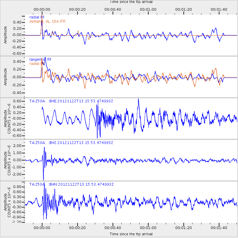
Z50A Ashland, AL, USA - Earthquake Result Viewer
*The percent match for this event was below the threshold and hence no stack was calculated.
| Earthquake location: |
Salta Province, Argentina |
| Earthquake latitude/longitude: |
-22.7/-63.6 |
| Earthquake time(UTC): |
2012/11/22 (327) 13:07:10 GMT |
| Earthquake Depth: |
517 km |
| Earthquake Magnitude: |
5.6 MB, 5.9 MW, 6.0 MW |
| Earthquake Catalog/Contributor: |
WHDF/NEIC |
|
| Network: |
TA USArray Transportable Network (new EarthScope stations) |
| Station: |
Z50A Ashland, AL, USA |
| Lat/Lon: |
33.25 N/85.92 W |
| Elevation: |
370 m |
|
| Distance: |
59.6 deg |
| Az: |
338.324 deg |
| Baz: |
155.988 deg |
| Ray Param: |
$rayparam |
*The percent match for this event was below the threshold and hence was not used in the summary stack. |
|
| Radial Match: |
60.27732 % |
| Radial Bump: |
400 |
| Transverse Match: |
54.024685 % |
| Transverse Bump: |
400 |
| SOD ConfigId: |
486959 |
| Insert Time: |
2013-03-21 20:17:44.208 +0000 |
| GWidth: |
2.5 |
| Max Bumps: |
400 |
| Tol: |
0.001 |
|
Signal To Noise
| Channel | StoN | STA | LTA |
| TA:Z50A: :BHZ:20121122T13:15:53.474993Z | 5.709872 | 7.5776114E-7 | 1.3271071E-7 |
| TA:Z50A: :BHN:20121122T13:15:53.474993Z | 3.0136344 | 4.5418295E-7 | 1.5070937E-7 |
| TA:Z50A: :BHE:20121122T13:15:53.474993Z | 1.6322763 | 2.4355234E-7 | 1.4921024E-7 |
| Arrivals |
| Ps | |
| PpPs | |
| PsPs/PpSs | |


