You are here: Home > Network List > TA - USArray Transportable Network (new EarthScope stations) Stations List
> Station J49A Marlette, MI, USA > Earthquake Result Viewer
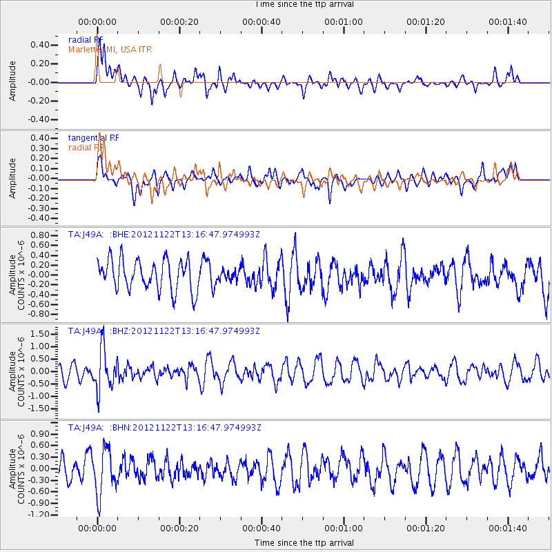
J49A Marlette, MI, USA - Earthquake Result Viewer
*The percent match for this event was below the threshold and hence no stack was calculated.
| Earthquake location: |
Salta Province, Argentina |
| Earthquake latitude/longitude: |
-22.7/-63.6 |
| Earthquake time(UTC): |
2012/11/22 (327) 13:07:10 GMT |
| Earthquake Depth: |
517 km |
| Earthquake Magnitude: |
5.6 MB, 5.9 MW, 6.0 MW |
| Earthquake Catalog/Contributor: |
WHDF/NEIC |
|
| Network: |
TA USArray Transportable Network (new EarthScope stations) |
| Station: |
J49A Marlette, MI, USA |
| Lat/Lon: |
43.36 N/83.14 W |
| Elevation: |
253 m |
|
| Distance: |
68.2 deg |
| Az: |
344.746 deg |
| Baz: |
160.548 deg |
| Ray Param: |
$rayparam |
*The percent match for this event was below the threshold and hence was not used in the summary stack. |
|
| Radial Match: |
63.54953 % |
| Radial Bump: |
400 |
| Transverse Match: |
58.678818 % |
| Transverse Bump: |
400 |
| SOD ConfigId: |
486959 |
| Insert Time: |
2013-03-21 20:27:09.131 +0000 |
| GWidth: |
2.5 |
| Max Bumps: |
400 |
| Tol: |
0.001 |
|
Signal To Noise
| Channel | StoN | STA | LTA |
| TA:J49A: :BHZ:20121122T13:16:47.974993Z | 2.3783934 | 8.594441E-7 | 3.6135492E-7 |
| TA:J49A: :BHN:20121122T13:16:47.974993Z | 2.4368858 | 5.882674E-7 | 2.414013E-7 |
| TA:J49A: :BHE:20121122T13:16:47.974993Z | 0.3134555 | 9.7023495E-8 | 3.0952876E-7 |
| Arrivals |
| Ps | |
| PpPs | |
| PsPs/PpSs | |


