You are here: Home > Network List > TA - USArray Transportable Network (new EarthScope stations) Stations List
> Station R11A Troy Canyon, Currant, NV, USA > Earthquake Result Viewer
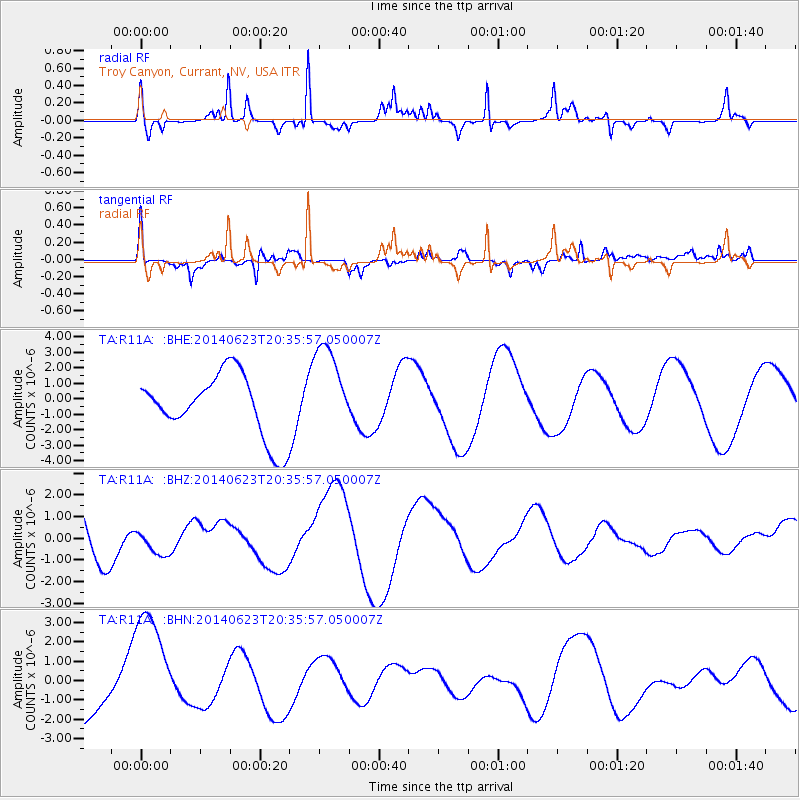
R11A Troy Canyon, Currant, NV, USA - Earthquake Result Viewer
*The percent match for this event was below the threshold and hence no stack was calculated.
| Earthquake location: |
Kermadec Islands, New Zealand |
| Earthquake latitude/longitude: |
-30.1/-177.3 |
| Earthquake time(UTC): |
2014/06/23 (174) 20:23:36 GMT |
| Earthquake Depth: |
35 km |
| Earthquake Magnitude: |
5.2 mb |
| Earthquake Catalog/Contributor: |
ISC/ISC |
|
| Network: |
TA USArray Transportable Network (new EarthScope stations) |
| Station: |
R11A Troy Canyon, Currant, NV, USA |
| Lat/Lon: |
38.35 N/115.59 W |
| Elevation: |
1756 m |
|
| Distance: |
89.2 deg |
| Az: |
43.819 deg |
| Baz: |
229.722 deg |
| Ray Param: |
$rayparam |
*The percent match for this event was below the threshold and hence was not used in the summary stack. |
|
| Radial Match: |
58.452274 % |
| Radial Bump: |
224 |
| Transverse Match: |
68.32732 % |
| Transverse Bump: |
351 |
| SOD ConfigId: |
3390531 |
| Insert Time: |
2019-04-12 10:17:13.454 +0000 |
| GWidth: |
2.5 |
| Max Bumps: |
400 |
| Tol: |
0.001 |
|
Signal To Noise
| Channel | StoN | STA | LTA |
| TA:R11A: :BHZ:20140623T20:35:57.050007Z | 0.38378483 | 6.4490666E-7 | 1.680386E-6 |
| TA:R11A: :BHN:20140623T20:35:57.050007Z | 2.6165497 | 3.176753E-6 | 1.2141E-6 |
| TA:R11A: :BHE:20140623T20:35:57.050007Z | 1.4823875 | 3.0091949E-6 | 2.029965E-6 |
| Arrivals |
| Ps | |
| PpPs | |
| PsPs/PpSs | |


