You are here: Home > Network List > CZ - Czech Regional Seismic Network Stations List
> Station DPC Dobruska, Czech Republic > Earthquake Result Viewer
DPC Dobruska, Czech Republic - Earthquake Result Viewer
| Earthquake location: |
Kuril Islands |
| Earthquake latitude/longitude: |
43.2/146.4 |
| Earthquake time(UTC): |
1997/07/14 (195) 16:09:35 GMT |
| Earthquake Depth: |
33 km |
| Earthquake Magnitude: |
5.9 MB, 5.8 MS, 6.1 UNKNOWN, 5.8 ME |
| Earthquake Catalog/Contributor: |
WHDF/NEIC |
|
| Network: |
CZ Czech Regional Seismic Network |
| Station: |
DPC Dobruska, Czech Republic |
| Lat/Lon: |
50.36 N/16.41 E |
| Elevation: |
760 m |
|
| Distance: |
77.1 deg |
| Az: |
329.759 deg |
| Baz: |
35.067 deg |
| Ray Param: |
0.05052018 |
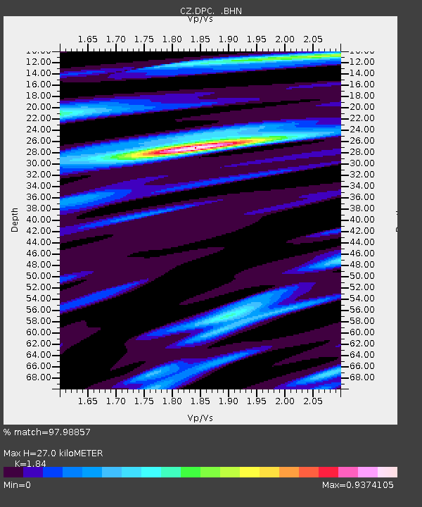
| Estimated Moho Depth: |
27.0 km |
| Estimated Crust Vp/Vs: |
1.84 |
| Assumed Crust Vp: |
6.194 km/s |
| Estimated Crust Vs: |
3.366 km/s |
| Estimated Crust Poisson's Ratio: |
0.29 |
|
| Radial Match: |
97.98857 % |
| Radial Bump: |
303 |
| Transverse Match: |
91.93567 % |
| Transverse Bump: |
400 |
| SOD ConfigId: |
6273 |
| Insert Time: |
2010-02-27 01:14:48.014 +0000 |
| GWidth: |
2.5 |
| Max Bumps: |
400 |
| Tol: |
0.001 |
|
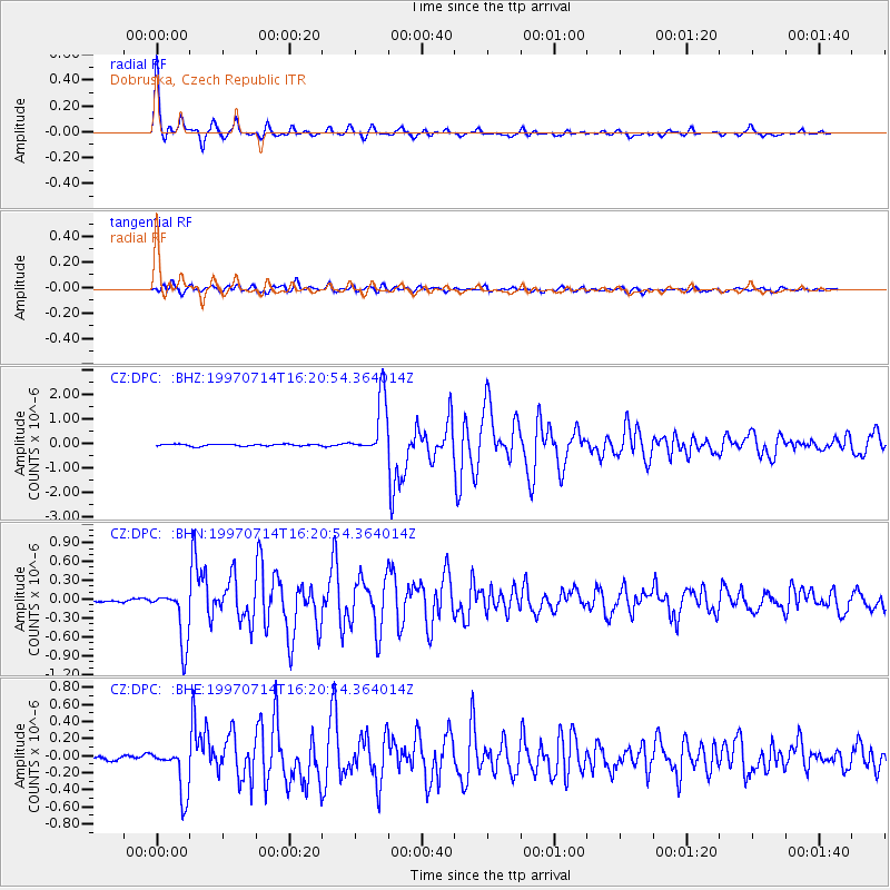
Signal To Noise
| Channel | StoN | STA | LTA |
| CZ:DPC: :BHN:19970714T16:20:54.364014Z | 22.48772 | 4.3565586E-7 | 1.9373056E-8 |
| CZ:DPC: :BHE:19970714T16:20:54.364014Z | 10.806278 | 2.858422E-7 | 2.6451492E-8 |
| CZ:DPC: :BHZ:19970714T16:20:54.364014Z | 29.801407 | 1.1742535E-6 | 3.940262E-8 |
| Arrivals |
| Ps | 3.8 SECOND |
| PpPs | 12 SECOND |
| PsPs/PpSs | 16 SECOND |


