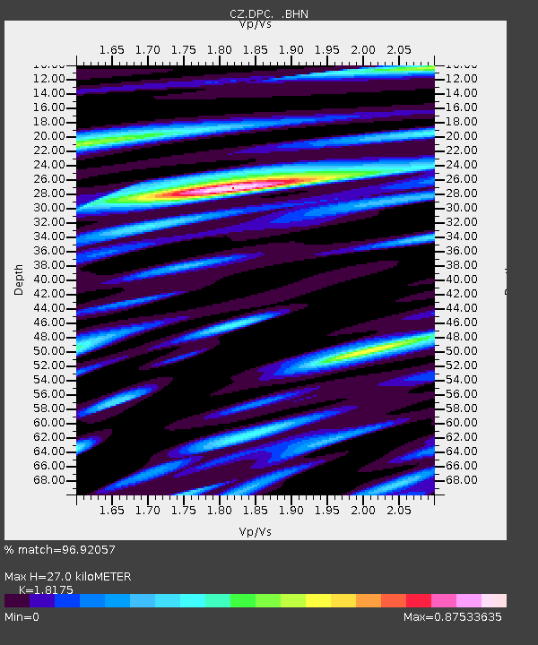
DPC Dobruska, Czech Republic - Earthquake Result Viewer
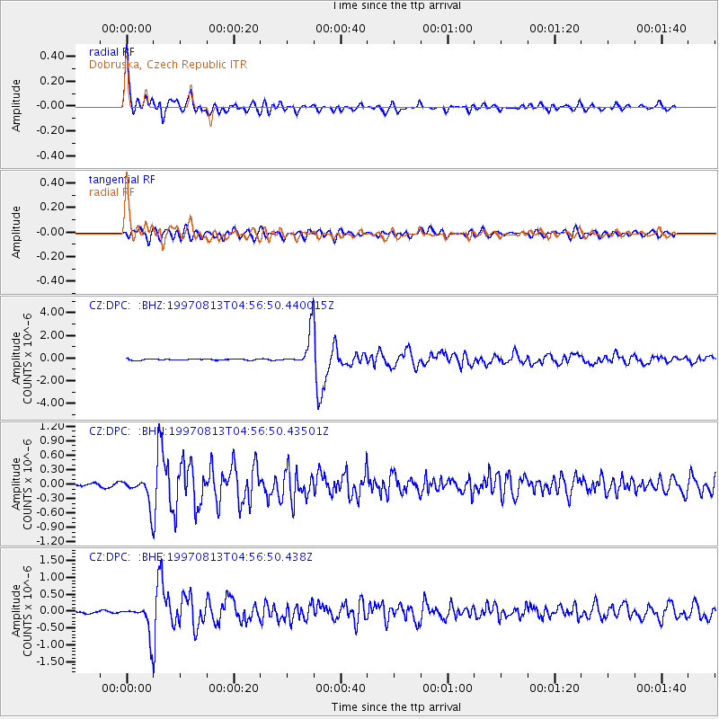
Earthquake location: Southwestern Ryukyu Isl., Japan
Earthquake latitude/longitude: 25.0/125.8
Earthquake time(UTC): 1997/08/13 (225) 04:45:04 GMT
Earthquake Depth: 55 km
Earthquake Magnitude: 6.0 MB, 5.6 MS, 6.1 UNKNOWN, 6.1 MW
Earthquake Catalog/Contributor: WHDF/NEIC
Network: CZ Czech Regional Seismic Network
Station: DPC Dobruska, Czech Republic
Lat/Lon: 50.36 N/16.41 E
Elevation: 760 m
Distance: 82.5 deg
Az: 322.445 deg
Baz: 59.685 deg
Ray Param: 0.046744198
Estimated Moho Depth: 27.0 km
Estimated Crust Vp/Vs: 1.82
Assumed Crust Vp: 6.194 km/s
Estimated Crust Vs: 3.408 km/s
Estimated Crust Poisson's Ratio: 0.28
Radial Match: 96.92057 %
Radial Bump: 400
Transverse Match: 86.52974 %
Transverse Bump: 400
SOD ConfigId: 6273
Insert Time: 2010-02-27 01:14:50.552 +0000
GWidth: 2.5
Max Bumps: 400
Tol: 0.001

Signal To Noise

ChannelStoNSTALTA
CZ:DPC: :BHN:19970813T04:56:50.43501Z9.5055922.9885084E-73.1439477E-8
CZ:DPC: :BHE:19970813T04:56:50.438Z15.2475754.673662E-73.065184E-8
CZ:DPC: :BHZ:19970813T04:56:50.440015Z30.3051761.5130895E-64.9928417E-8
Arrivals
Ps3.6 SECOND
PpPs12 SECOND
PsPs/PpSs16 SECOND