You are here: Home > Network List > CI - Caltech Regional Seismic Network Stations List
> Station LRL Laurel Mtn Radio Fac, Ridgecrest, CA, USA > Earthquake Result Viewer
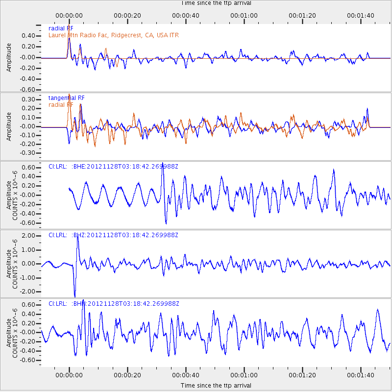
LRL Laurel Mtn Radio Fac, Ridgecrest, CA, USA - Earthquake Result Viewer
*The percent match for this event was below the threshold and hence no stack was calculated.
| Earthquake location: |
Northern Peru |
| Earthquake latitude/longitude: |
-4.5/-76.1 |
| Earthquake time(UTC): |
2012/11/28 (333) 03:09:48 GMT |
| Earthquake Depth: |
118 km |
| Earthquake Magnitude: |
5.9 MB, 5.6 MW, 5.7 MW |
| Earthquake Catalog/Contributor: |
WHDF/NEIC |
|
| Network: |
CI Caltech Regional Seismic Network |
| Station: |
LRL Laurel Mtn Radio Fac, Ridgecrest, CA, USA |
| Lat/Lon: |
35.48 N/117.68 W |
| Elevation: |
1340 m |
|
| Distance: |
55.7 deg |
| Az: |
319.034 deg |
| Baz: |
126.791 deg |
| Ray Param: |
$rayparam |
*The percent match for this event was below the threshold and hence was not used in the summary stack. |
|
| Radial Match: |
66.431244 % |
| Radial Bump: |
359 |
| Transverse Match: |
45.24183 % |
| Transverse Bump: |
368 |
| SOD ConfigId: |
486959 |
| Insert Time: |
2013-03-23 04:18:09.141 +0000 |
| GWidth: |
2.5 |
| Max Bumps: |
400 |
| Tol: |
0.001 |
|
Signal To Noise
| Channel | StoN | STA | LTA |
| CI:LRL: :BHZ:20121128T03:18:42.269988Z | 5.641558 | 9.4094264E-7 | 1.6678773E-7 |
| CI:LRL: :BHN:20121128T03:18:42.269988Z | 2.3538992 | 2.6690583E-7 | 1.1338881E-7 |
| CI:LRL: :BHE:20121128T03:18:42.269988Z | 1.9445143 | 3.0837157E-7 | 1.585854E-7 |
| Arrivals |
| Ps | |
| PpPs | |
| PsPs/PpSs | |


