You are here: Home > Network List > CI - Caltech Regional Seismic Network Stations List
> Station MPM Manuel Prospect Mine, California, USA > Earthquake Result Viewer
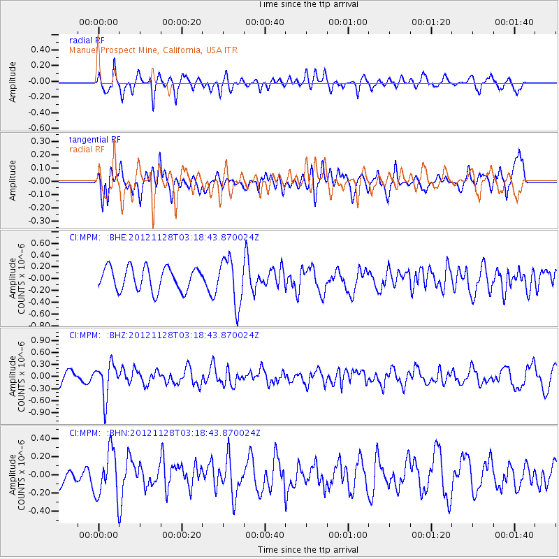
MPM Manuel Prospect Mine, California, USA - Earthquake Result Viewer
*The percent match for this event was below the threshold and hence no stack was calculated.
| Earthquake location: |
Northern Peru |
| Earthquake latitude/longitude: |
-4.5/-76.1 |
| Earthquake time(UTC): |
2012/11/28 (333) 03:09:48 GMT |
| Earthquake Depth: |
118 km |
| Earthquake Magnitude: |
5.9 MB, 5.6 MW, 5.7 MW |
| Earthquake Catalog/Contributor: |
WHDF/NEIC |
|
| Network: |
CI Caltech Regional Seismic Network |
| Station: |
MPM Manuel Prospect Mine, California, USA |
| Lat/Lon: |
36.06 N/117.49 W |
| Elevation: |
185 m |
|
| Distance: |
55.9 deg |
| Az: |
319.705 deg |
| Baz: |
127.281 deg |
| Ray Param: |
$rayparam |
*The percent match for this event was below the threshold and hence was not used in the summary stack. |
|
| Radial Match: |
57.132927 % |
| Radial Bump: |
343 |
| Transverse Match: |
58.064693 % |
| Transverse Bump: |
394 |
| SOD ConfigId: |
486959 |
| Insert Time: |
2013-03-23 04:19:04.400 +0000 |
| GWidth: |
2.5 |
| Max Bumps: |
400 |
| Tol: |
0.001 |
|
Signal To Noise
| Channel | StoN | STA | LTA |
| CI:MPM: :BHZ:20121128T03:18:43.870024Z | 2.1389892 | 4.3709827E-7 | 2.0434805E-7 |
| CI:MPM: :BHN:20121128T03:18:43.870024Z | 2.0109622 | 2.61964E-7 | 1.3026799E-7 |
| CI:MPM: :BHE:20121128T03:18:43.870024Z | 2.078459 | 4.057912E-7 | 1.9523658E-7 |
| Arrivals |
| Ps | |
| PpPs | |
| PsPs/PpSs | |


