You are here: Home > Network List > 1U - Mt. Paektu Seismic Network Stations List
> Station SHRD Sin Hung Ri > Earthquake Result Viewer
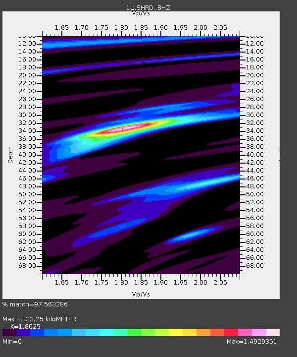
SHRD Sin Hung Ri - Earthquake Result Viewer
| Earthquake location: |
Rat Islands, Aleutian Islands |
| Earthquake latitude/longitude: |
51.8/178.8 |
| Earthquake time(UTC): |
2014/06/23 (174) 20:53:09 GMT |
| Earthquake Depth: |
108 km |
| Earthquake Magnitude: |
7.9 MWW, 7.1 MI, 7.9 MWC |
| Earthquake Catalog/Contributor: |
NEIC PDE/NEIC COMCAT |
|
| Network: |
1U Mt. Paektu Seismic Network |
| Station: |
SHRD Sin Hung Ri |
| Lat/Lon: |
41.95 N/128.79 E |
| Elevation: |
1041 m |
|
| Distance: |
34.9 deg |
| Az: |
273.752 deg |
| Baz: |
56.167 deg |
| Ray Param: |
0.07714883 |
| Estimated Moho Depth: |
33.25 km |
| Estimated Crust Vp/Vs: |
1.80 |
| Assumed Crust Vp: |
6.472 km/s |
| Estimated Crust Vs: |
3.59 km/s |
| Estimated Crust Poisson's Ratio: |
0.28 |
|
| Radial Match: |
97.563286 % |
| Radial Bump: |
233 |
| Transverse Match: |
83.82517 % |
| Transverse Bump: |
400 |
| SOD ConfigId: |
3390531 |
| Insert Time: |
2019-04-12 10:23:53.800 +0000 |
| GWidth: |
2.5 |
| Max Bumps: |
400 |
| Tol: |
0.001 |
|

Signal To Noise
| Channel | StoN | STA | LTA |
| 1U:SHRD: :BHZ:20140623T20:59:20.980Z | 5.4211073 | 8.536941E-6 | 1.5747597E-6 |
| 1U:SHRD: :BHN:20140623T20:59:20.980Z | 5.4760547 | 2.7812325E-6 | 5.0788987E-7 |
| 1U:SHRD: :BHE:20140623T20:59:20.980Z | 3.43915 | 4.6691275E-6 | 1.3576399E-6 |
| Arrivals |
| Ps | 4.4 SECOND |
| PpPs | 13 SECOND |
| PsPs/PpSs | 18 SECOND |


