You are here: Home > Network List > CI - Caltech Regional Seismic Network Stations List
> Station SMM Simmler, CA, USA > Earthquake Result Viewer
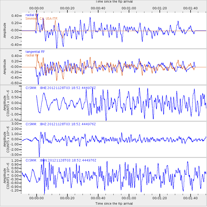
SMM Simmler, CA, USA - Earthquake Result Viewer
*The percent match for this event was below the threshold and hence no stack was calculated.
| Earthquake location: |
Northern Peru |
| Earthquake latitude/longitude: |
-4.5/-76.1 |
| Earthquake time(UTC): |
2012/11/28 (333) 03:09:48 GMT |
| Earthquake Depth: |
118 km |
| Earthquake Magnitude: |
5.9 MB, 5.6 MW, 5.7 MW |
| Earthquake Catalog/Contributor: |
WHDF/NEIC |
|
| Network: |
CI Caltech Regional Seismic Network |
| Station: |
SMM Simmler, CA, USA |
| Lat/Lon: |
35.31 N/120.00 W |
| Elevation: |
599 m |
|
| Distance: |
57.1 deg |
| Az: |
317.549 deg |
| Baz: |
124.636 deg |
| Ray Param: |
$rayparam |
*The percent match for this event was below the threshold and hence was not used in the summary stack. |
|
| Radial Match: |
52.458523 % |
| Radial Bump: |
400 |
| Transverse Match: |
78.60821 % |
| Transverse Bump: |
400 |
| SOD ConfigId: |
486959 |
| Insert Time: |
2013-03-23 04:19:58.367 +0000 |
| GWidth: |
2.5 |
| Max Bumps: |
400 |
| Tol: |
0.001 |
|
Signal To Noise
| Channel | StoN | STA | LTA |
| CI:SMM: :BHZ:20121128T03:18:52.444976Z | 7.4178104 | 1.0499813E-6 | 1.4154868E-7 |
| CI:SMM: :BHN:20121128T03:18:52.444976Z | 1.9452074 | 5.3607334E-7 | 2.7558673E-7 |
| CI:SMM: :BHE:20121128T03:18:52.444976Z | 1.3496462 | 5.499038E-7 | 4.0744294E-7 |
| Arrivals |
| Ps | |
| PpPs | |
| PsPs/PpSs | |


